IMAGES TAKEN NEAR TO
Park Lane, NOTTINGHAM, NG17 9LB
Introduction
This page details the photographs taken nearby to Park Lane, NG17 9LB by members of the Geograph project.
The Geograph project started in 2005 with the aim of publishing, organising and preserving representative images for every square kilometre of Great Britain, Ireland and the Isle of Man.

There are currently over 7.5m images from over14,400 individuals and you can help contribute to the project by visiting https://www.geograph.org.uk
Image Map
Images are licensed for reuse under creativecommons.org/licenses/by-sa/2.0
Notes
- Clicking on the map will re-center to the selected point.
- The higher the marker number, the further away the image location is from the centre of the postcode.
Image Listing (14 Images Found)
Images are licensed for reuse under creativecommons.org/licenses/by-sa/2.0
Image
Details
Distance

2
![Restored land, north of Park Lane [2]](https://s1.geograph.org.uk/geophotos/05/50/62/5506205_ae24d012_120x120.jpg)
Restored land, north of Park Lane [2]
Possibly now used as a paddock. Looking north-west from a blocked gateway. This was either a spoil heap or an opencast site, I am not sure.
Image: © Christine Johnstone
Taken: 19 Aug 2017
0.07 miles
3
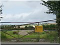
'Danger Keep Out' sign on Park Lane
A blocked gateway to reinstated coal mining land, near High Cliff. The land is between the first and second Portland Collieries, and is [or was] owned by British Coal.
Image: © Christine Johnstone
Taken: 19 Aug 2017
0.08 miles


6
![Restored land, north of Park Lane [1]](https://s2.geograph.org.uk/geophotos/05/50/62/5506202_a7aea284_120x120.jpg)
Restored land, north of Park Lane [1]
Looking north-east from a blocked gateway. This was either a spoil heap or an opencast site, I am not sure.
Image: © Christine Johnstone
Taken: 19 Aug 2017
0.11 miles
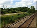
7
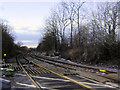
Railway crossing near Kirkby Woodhouse
Image: © Steve Fareham
Taken: 10 Dec 2007
0.14 miles
8
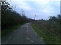
Works Track next to Mineral Railway
Image: © Jonathan Clitheroe
Taken: 5 Jan 2019
0.16 miles
9
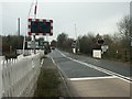
Level crossing, Bentinck Colliery
The colliery is now disused - the railway line appears not to be, as everything is well-maintained. It links the Nottingham-Chesterfield line at Pye Bridge to the Robin Hood Line at Kirkby in Ashfield.
Image: © Katy Walters
Taken: 4 Dec 2005
0.19 miles
10
Former railway junction to Portland Collieries
This is the former Midland Railway line from Langley Mill to Mansfield. This would once have been an industrial landscape with sidings full of coal wagons.
Image: © Nigel Thompson
Taken: 14 Jun 2017
0.19 miles