IMAGES TAKEN NEAR TO
Skegby Road, NOTTINGHAM, NG17 9JD
Introduction
This page details the photographs taken nearby to Skegby Road, NG17 9JD by members of the Geograph project.
The Geograph project started in 2005 with the aim of publishing, organising and preserving representative images for every square kilometre of Great Britain, Ireland and the Isle of Man.

There are currently over 7.5m images from over14,400 individuals and you can help contribute to the project by visiting https://www.geograph.org.uk
Image Map
Images are licensed for reuse under creativecommons.org/licenses/by-sa/2.0
Notes
- Clicking on the map will re-center to the selected point.
- The higher the marker number, the further away the image location is from the centre of the postcode.
Image Listing (22 Images Found)
Images are licensed for reuse under creativecommons.org/licenses/by-sa/2.0
Image
Details
Distance
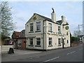
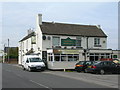
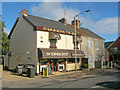
3
Competing pubs on Skegby Road
The General Havelock in the foreground and the Forest Tavern in the background. General Havelock was a Victorian military hero, whose death in India in 1857 resulted in a national outpouring of grief (and many place-names across the country).
Image: © Trevor Rickard
Taken: 16 Oct 2010
0.03 miles
4
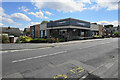
Co-op store on Skegby Road
This has been built on the site of the former pub the General Havelock. Many pub buildings are converted to stores, but this one has been completely rebuilt.
Image: © Bill Boaden
Taken: 3 Aug 2022
0.03 miles
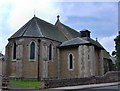
6
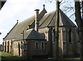
Annesley Woodhouse - St Johns Church
This is, more accurately, the Church of St John the Evangelist, Kirkby Woodhouse. St. John's was built as a daughter church to St. Wilfrid's Church, Kirkby-in-Ashfield. The present building was constructed in 1906 on Skegby Road. The land was donated by the sixth Duke of Portland and the church cost £10,000. The plans for a tower were never realised.
Interestingly, the mother church, St Wilfrid's Church was destroyed by fire and rebuilt in 1908 by L. Ambler in a neo Early English style, again at the expense of the sixth Duke of Portland.
A further anglican church in the vicinity is Annesley All Saints Church. Like St Wilfrid's, this was badly damaged by fire (in 1907), rebuilt and re-opened in 1909.
For an alternative view of St John's Church, please see Image
Image: © Dave Bevis
Taken: 16 Feb 2013
0.05 miles
7
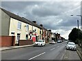
Annesley Woodhouse Post Office
Post Office and dwellings located on Forest Road.
Image: © Jonathan Clitheroe
Taken: 15 Jul 2022
0.11 miles
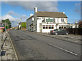
8
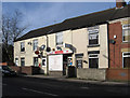
Annesley Woodhouse - Post Office on Forest Road
Image: © Dave Bevis
Taken: 16 Feb 2013
0.11 miles
9
The Upper Crust
Cafe and takeaway on Forest Road.
http://www.theuppercrustcafe.co.uk/
Image: © Trevor Rickard
Taken: 16 Oct 2010
0.11 miles
10
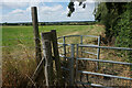
Footpath by Sycamore Farm
Leaving Annesley Woodhouse in the direction of the M1 motorway.
Image: © Bill Boaden
Taken: 3 Aug 2022
0.11 miles