IMAGES TAKEN NEAR TO
Park Lane Business Park, Park Lane, NOTTINGHAM, NG17 9GU
Introduction
This page details the photographs taken nearby to Park Lane Business Park, Park Lane, NG17 9GU by members of the Geograph project.
The Geograph project started in 2005 with the aim of publishing, organising and preserving representative images for every square kilometre of Great Britain, Ireland and the Isle of Man.

There are currently over 7.5m images from over14,400 individuals and you can help contribute to the project by visiting https://www.geograph.org.uk
Image Map
Images are licensed for reuse under creativecommons.org/licenses/by-sa/2.0
Notes
- Clicking on the map will re-center to the selected point.
- The higher the marker number, the further away the image location is from the centre of the postcode.
Image Listing (14 Images Found)
Images are licensed for reuse under creativecommons.org/licenses/by-sa/2.0
Image
Details
Distance
1
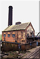
Bentinck Colliery winding engine house.
The colliery originally had three steam winding engines and this one was temporarily "preserved" when the others were scrapped. The remains of the head-gear still cling to the front wall. The shaft remained in use with new head-gear from a different direction.
Image: © Chris Allen
Taken: 20 Feb 1988
0.05 miles
2
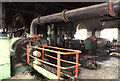
Bentinck Colliery steam winding engine
Built by John Warner & Son of Hanley c1890 and installed here 2nd hand in 1915. Stopped 1978/9 and finally scrapped 1991. On an earlier visit they put steam on and limped it round for us. I have a horrible feeling that on this occasion we "bunked it" without permission - with a live colliery around it.
Image: © Chris Allen
Taken: 20 Feb 1988
0.05 miles
3
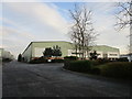
Furniture warehouse on the site of Bentinck Colliery
Image: © Jonathan Thacker
Taken: 29 Dec 2019
0.07 miles
4
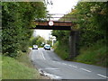
Disused railway bridge crossing Park Lane
This once carried a line into Bentink Colliery.
Image: © Christine Johnstone
Taken: 19 Aug 2017
0.14 miles
5
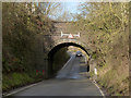
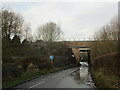
Low bridge, Mill Lane
This originally carried rail connections from Bentinck Colliery east onto both the Midland Railway Mansfield branch and the Great Central Railway, but was latterly simply an internal colliery siding. The clearance is very limited, signed for 10 ft.
Image: © Alan Murray-Rust
Taken: 30 Nov 2014
0.16 miles
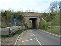
6
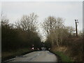
Former railway bridge, Mill Lane
Once carried the Great Central Main Line from Manchester to London Marylebone.
Image: © Jonathan Thacker
Taken: 29 Dec 2019
0.16 miles
7
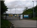
Entrance to Severn Trent Water's sewage treatment works
On the west side of Park Lane [B6018].
Image: © Christine Johnstone
Taken: 19 Aug 2017
0.16 miles
8
Railway bridge, Mill Lane
Carries a freight only line from Kirkby in Ashfield to Pye Bridge. There is talk of re-opening this line to passengers with a service from Mansfield to Derby in connection with the opening of HS2.
Image: © Jonathan Thacker
Taken: 29 Dec 2019
0.19 miles