IMAGES TAKEN NEAR TO
Butlerwood Close, NOTTINGHAM, NG17 9GR
Introduction
This page details the photographs taken nearby to Butlerwood Close, NG17 9GR by members of the Geograph project.
The Geograph project started in 2005 with the aim of publishing, organising and preserving representative images for every square kilometre of Great Britain, Ireland and the Isle of Man.

There are currently over 7.5m images from over14,400 individuals and you can help contribute to the project by visiting https://www.geograph.org.uk
Image Map
Images are licensed for reuse under creativecommons.org/licenses/by-sa/2.0
Notes
- Clicking on the map will re-center to the selected point.
- The higher the marker number, the further away the image location is from the centre of the postcode.
Image Listing (18 Images Found)
Images are licensed for reuse under creativecommons.org/licenses/by-sa/2.0
Image
Details
Distance
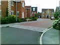
2
Sherwood Dene
A fairly new estate in Kirkby Woodhouse.
Image: © Bill Boaden
Taken: 3 Aug 2022
0.03 miles
3

Footpath, Kirkby Woodhouse
Looking towards Kirkby Cross - St Wilfrid's Church is hidden behind the tree.
Image: © Katy Walters
Taken: 4 Dec 2005
0.09 miles
4
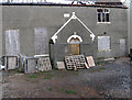
Annesley Woodhouse - General Baptist Chapel
This shows the remains of the Baptist Chapel on Main Road, Kirkby Woodhouse. A Baptist meeting was held in a house in Kirkby Woodhouse as early as 1749, and by 1754 the community had developed enough to build a chapel. In 1773, the congregation joined the New Connection of General Baptists. In 1818, the chapel at Kirkby Woodhouse was enlarged.
Image: © Dave Bevis
Taken: 16 Feb 2013
0.12 miles
5
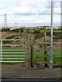
Squeeze stile
Modern version of a traditional form.
Image: © Alan Murray-Rust
Taken: 30 Nov 2014
0.12 miles
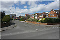
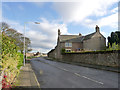
6
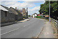
Main Road, Kirkby Woodhouse
The buildings here appear to be older than most in the locality.
Image: © Bill Boaden
Taken: 3 Aug 2022
0.12 miles
7
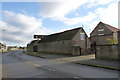
Barn at Prospect Farm
Stone barn, probably early 19th century.
Image: © Alan Murray-Rust
Taken: 30 Nov 2014
0.12 miles
8
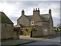
Prospect Farm, Kirkby Woodhouse
Mid 18th century farmhouse, extended mid 19th century. Listed Grade II, including the garden wall.
Image: © Alan Murray-Rust
Taken: 30 Nov 2014
0.13 miles
9
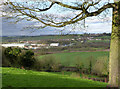
View from Kirkby Woodhouse
The industrial estate is on the site of Bentinck Colliery. This area was for a long period one where mining and agriculture worked side by side.
Image: © Alan Murray-Rust
Taken: 30 Nov 2014
0.13 miles
10
Prospect Farm, Kirkby Woodhouse
Mid 18th century farmhouse, extended mid 19th century. Listed Grade II, including the garden wall.
Image: © Alan Murray-Rust
Taken: 30 Nov 2014
0.13 miles