IMAGES TAKEN NEAR TO
Northrowe, NOTTINGHAM, NG17 9FU
Introduction
This page details the photographs taken nearby to Northrowe, NG17 9FU by members of the Geograph project.
The Geograph project started in 2005 with the aim of publishing, organising and preserving representative images for every square kilometre of Great Britain, Ireland and the Isle of Man.

There are currently over 7.5m images from over14,400 individuals and you can help contribute to the project by visiting https://www.geograph.org.uk
Image Map
Images are licensed for reuse under creativecommons.org/licenses/by-sa/2.0
Notes
- Clicking on the map will re-center to the selected point.
- The higher the marker number, the further away the image location is from the centre of the postcode.
Image Listing (8 Images Found)
Images are licensed for reuse under creativecommons.org/licenses/by-sa/2.0
Image
Details
Distance
1
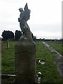
Cemetery, Annesley Woodhouse
A small cemetery tucked away behind a new housing estate at Church View Gardens, off Skegby Road.
Image: © Katy Walters
Taken: 4 Dec 2005
0.11 miles
2
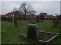
Cemetery, Annesley Woodhouse
On the edge of both Annesley Woodhouse and Kirkby Woodhouse, this cemetery is now bordered by a new estate.
Image: © Katy Walters
Taken: 4 Dec 2005
0.12 miles
3
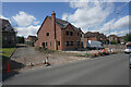
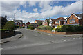
New housing in Annesley Woodhouse
Constructed on an existing housing site.
Image: © Bill Boaden
Taken: 3 Aug 2022
0.17 miles
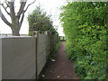
5
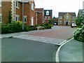
Sherwood Dene
A fairly new estate in Kirkby Woodhouse.
Image: © Bill Boaden
Taken: 3 Aug 2022
0.22 miles
6
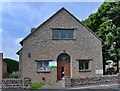
Annesley Woodhouse Library
Formerly the St John's Church hall.
Image: © Phil Evans
Taken: 24 Jul 2008
0.23 miles
8
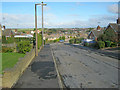
Skegby Road
Heading north through a quiet residential area.
Image: © Trevor Rickard
Taken: 16 Oct 2010
0.24 miles