IMAGES TAKEN NEAR TO
Albert Close, NOTTINGHAM, NG17 9AQ
Introduction
This page details the photographs taken nearby to Albert Close, NG17 9AQ by members of the Geograph project.
The Geograph project started in 2005 with the aim of publishing, organising and preserving representative images for every square kilometre of Great Britain, Ireland and the Isle of Man.

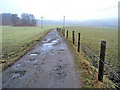
There are currently over 7.5m images from over14,400 individuals and you can help contribute to the project by visiting https://www.geograph.org.uk
Image Map
Images are licensed for reuse under creativecommons.org/licenses/by-sa/2.0
Notes
- Clicking on the map will re-center to the selected point.
- The higher the marker number, the further away the image location is from the centre of the postcode.
Image Listing (26 Images Found)
Images are licensed for reuse under creativecommons.org/licenses/by-sa/2.0
Image
Details
Distance
1
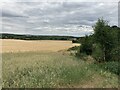
Crop Field near Annesley
Wooded area adjoining farmland to the east of Annesley.
Image: © Jonathan Clitheroe
Taken: 15 Jul 2022
0.08 miles
2
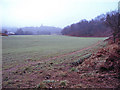
Arable land east of Annesley
Looking south to the spire of All Saints Church just showing through the mist. The flat valley bottom here is arable and grassland, which also provides several unofficial paths for Annesley dog walkers. The steep bracken-clad slope on the right leads up to Annesley, which is built right up to its top edge.
Image: © Trevor Rickard
Taken: 6 Feb 2010
0.11 miles
3
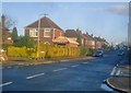
Seagrave Avenue
Looking east off the main Derby Road, which has another section running parallel to it - left and right off this picture.
Image: © Trevor Rickard
Taken: 24 Oct 2009
0.13 miles
4
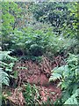
Site of Robin Hood's Cave near Annesley
Romantically associated with the famous outlaw who would sit here at the cave entrance surveying the wealthy travellers passing through the valley below carrying their valuable wares. A very helpful local chap who lives nearby explained how him and other local children would play in the cave before the unstable sandstone bedrock led to the local council infilling the site. There's nothing to see now really - the area is obscured by heavy bracken, gorse and sycamore undergrowth, some of which I had to scrape away to even obtain this picture. One for the imagination I guess...
Image: © Jonathan Clitheroe
Taken: 15 Jul 2022
0.15 miles
5
Track north of Annesley Village
Heading north into the mist and to the riding school on the right just across the railway.
Image: © Trevor Rickard
Taken: 6 Feb 2010
0.16 miles
6
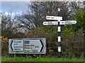
Fingerpost at Shoulder of Mutton Hill
Notts C C octagonal concrete post with slotted arms and octagonal cast-iron finial. An unusual survivor at a junction of classified roads, still standing alongside its modern counterpart.
Image: © Alan Murray-Rust
Taken: 30 Nov 2014
0.17 miles
7
Looking down Shoulder of Mutton Hill
A sharp rise up to the ridge forming Robin Hood's Hills. Behind the camera the land falls away again even more steeply.
Image: © Alan Murray-Rust
Taken: 30 Nov 2014
0.18 miles
8
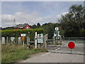
Level Crossing, Annesley Village
these are just north of the village on a farm track
Image: © Tom Courtney
Taken: 15 Aug 2005
0.19 miles
9

Fields near Annesley
Looking across the fields from the outskirts of Annesley towards the Robin Hood Line, with Robin Hood's Hills beyond.
Image: © Antony Dixon
Taken: 27 Jul 2016
0.20 miles
10
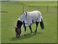
Grazing Pony, Newstead
I am not lifting my head for a photo ..... and yes it is this year's fashion !
Image: © Phil Evans
Taken: 24 Jul 2008
0.21 miles