IMAGES TAKEN NEAR TO
North Street, NOTTINGHAM, NG17 9AN
Introduction
This page details the photographs taken nearby to North Street, NG17 9AN by members of the Geograph project.
The Geograph project started in 2005 with the aim of publishing, organising and preserving representative images for every square kilometre of Great Britain, Ireland and the Isle of Man.

There are currently over 7.5m images from over14,400 individuals and you can help contribute to the project by visiting https://www.geograph.org.uk
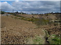
Image Map
Images are licensed for reuse under creativecommons.org/licenses/by-sa/2.0
Notes
- Clicking on the map will re-center to the selected point.
- The higher the marker number, the further away the image location is from the centre of the postcode.
Image Listing (21 Images Found)
Images are licensed for reuse under creativecommons.org/licenses/by-sa/2.0
Image
Details
Distance
1
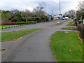
(Claimed) Highest Point in Nottinghamshire
Derby Road, just north of the Shoulder of Mutton junction. The gap in between the terraces has since been filled with more houses. The plaque between the upper windows of the closest house reads "AD 1904 - Highest Point in Notts - 609 feet above sea level".
The road clearly rises between this house and the corner, though, which is a clue that this plaque is not in its original location. Its story has received attention in the local "The Ad" paper (May 2009): a letter from John Harris of Langley Mill states that the plaque was affixed, in the year noted on it (1904) to the Castle Houses (originally the Imperial Cafe & Restaurant) further up the hill. The plaque is made of slate, and was fixed in its present position in or after the 1980s. Mr Harris helped remove it from the Castle Houses, researched its history, and refurbished it, and so this seems like a fairly definitive account!
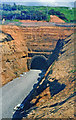
The current contender is Image, but landscaping is also going on at Silverhill Colliery, in Image - see the discussion thread associated with this square.
Image: © Katy Walters
Taken: 4 Dec 2005
0.03 miles
2
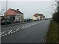
Not Notts highest point
Whilst waiting at the traffic lights, I glanced across Derby Road at this house because the plaque caught my eye. It reads "AD 1904 Highest Point in Notts 609 feet above sea level". Having come down this road and had to apply quite a lot of braking to stop, I pondered the sign for a whole minute before the penny dropped - there was something wrong! Luckily, a fellow Geographer had been here before - Image Fortunately, I'm going to stop worrying about this inconsistency, because in about a year's time, the growth will have covered the plaque and all will be well again.
Image: © Trevor Rickard
Taken: 10 Sep 2009
0.04 miles
3
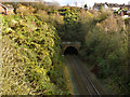
Kirkby Tunnel, west portal
Less than 200 yards long, it runs under the steep but narrow ridge forming Robin Hood's Hills.
It was built in 1848 by the Midland Railway as part of its route from Nottingham to Mansfield. The line closed in 1964, and the tunnel was later filled in. The Robin Hood Line project to restore passenger train services between Nottingham and Mansfield required the provision of a tunnel under Robin Hood's Hill, and studies showed that this tunnel was still in good condition. It was therefore reopened and passenger service resumed in 1995.
Image: © Alan Murray-Rust
Taken: 30 Nov 2014
0.06 miles
4
Robin Hood Line under construction through Kirkby-in-Ashfield (ex-Midland) Tunnel, 1995
View SE from the B6021 bridge. This had been the ex-Midland Nottingham - Mansfield - Worksop line until closed north of Newstead 12/10/70 (passenger services had ceased from 12/10/64). The new Robin Hood Line (Nottingham - Mansfield - Worksop) was diverted over the route through this tunnel because it was shorter than the ex-GCR one. The line was restored to Mansfield Woodhouse later in 1995 and to Worksop in 1998.
Image: © Ben Brooksbank
Taken: 27 May 1995
0.07 miles
5
Shoulder of Mutton Hill
A sharp rise up to the ridge forming Robin Hood's Hills
Image: © Alan Murray-Rust
Taken: 30 Nov 2014
0.07 miles
6
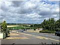
View from the A611 Road in Nuncargate
Pictured from a spot close to one of Nottinghamshire's points. An electrical substation can be seen in the middle distance.
Image: © Jonathan Clitheroe
Taken: 15 Jul 2022
0.08 miles
7
Looking down Shoulder of Mutton Hill
A sharp rise up to the ridge forming Robin Hood's Hills. Behind the camera the land falls away again even more steeply.
Image: © Alan Murray-Rust
Taken: 30 Nov 2014
0.08 miles
8
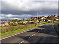
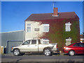
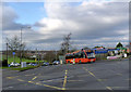
Near Shoulder of Mutton Hill
Older houses relating to the earlier mining industry mixed with later 20th century commuter-style development.
Image: © Alan Murray-Rust
Taken: 30 Nov 2014
0.09 miles
9
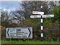
Fingerpost at Shoulder of Mutton Hill
Notts C C octagonal concrete post with slotted arms and octagonal cast-iron finial. An unusual survivor at a junction of classified roads, still standing alongside its modern counterpart.
Image: © Alan Murray-Rust
Taken: 30 Nov 2014
0.09 miles