IMAGES TAKEN NEAR TO
Millers Way, NOTTINGHAM, NG17 8RF
Introduction
This page details the photographs taken nearby to Millers Way, NG17 8RF by members of the Geograph project.
The Geograph project started in 2005 with the aim of publishing, organising and preserving representative images for every square kilometre of Great Britain, Ireland and the Isle of Man.

There are currently over 7.5m images from over14,400 individuals and you can help contribute to the project by visiting https://www.geograph.org.uk
Image Map
Images are licensed for reuse under creativecommons.org/licenses/by-sa/2.0
Notes
- Clicking on the map will re-center to the selected point.
- The higher the marker number, the further away the image location is from the centre of the postcode.
Image Listing (22 Images Found)
Images are licensed for reuse under creativecommons.org/licenses/by-sa/2.0
Image
Details
Distance
1
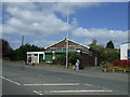
Ashfield Evergreens Recreation Centre
Old People Welfare Centre. Dancing, Bingo, Lunch Clubs, Resource Centre, Concerts and Disabled Centre.
Image: © JThomas
Taken: 18 Apr 2014
0.08 miles
2
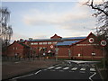
Ashfield District Council Offices
Date from 1986. An opportunity to provide some dignity to the centre of Kirkby in Ashfield was lost with the construction of these offices.
Image: © Jonathan Thacker
Taken: 29 Dec 2019
0.08 miles
3
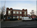
Former Kirkby Urban District Council offices
Dated 1932.
The Urban District was created in 1896 and abolished in 1974.
Image: © Jonathan Thacker
Taken: 29 Dec 2019
0.10 miles

5
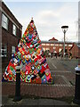
Kirkby Craft Bombers Christmas Tree
Image: © Jonathan Thacker
Taken: 29 Dec 2019
0.10 miles
6
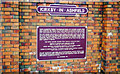
Kirkby-in-Ashfield: plaque at new station on Robin Hood Line, 2000
This new station was opened 17/11/96, on the newly-built (1995) section of the restored Robin Hood Line: Nottingham - Newstead May 1993, on to Mansfield Woodhouse 1995, Worksop 1998. [Text on the plaque should quite legible].
Image: © Ben Brooksbank
Taken: 3 Jul 2000
0.11 miles
7
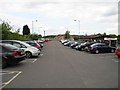
Kirkby in Ashfield Railway Station Car Park
Image: © John Topping
Taken: 25 Jun 2013
0.11 miles
8
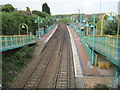
Kirkby in Ashfield railway station, Nottinghamshire
Opened in 1996 by British Rail on the Nottingham to Worksop "Robin Hood" line. View north towards Sutton Parkway and Worksop.
Whilst the northern and southern ends of the Robin Hood line used the previous Midland Railway line, the middle part around Kirkby and Sutton used the old Great Northern Railway Leen Valley extension, for various reasons. This resulted in the current station being built where there hadn't previously been one.
This image was taken before the later dark blue colour scheme was applied.
Image: © Nigel Thompson
Taken: 13 May 2010
0.11 miles
9
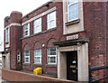
Kirkby-in-Ashfield - Ada Lovelace House
Built in 1933, these were the offices of the former Kirkby Urban District Council. The offices of the successor Ashfield District Council are behind this building.
Image: © Dave Bevis
Taken: 18 Nov 2010
0.11 miles
10
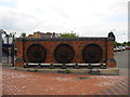
Three Locomotive Wheels, Kirkby-in-Ashfield Railway Station.
These locomotive wheels commemorate Kirkby as an historic railway town and celebrate the opening of the new Kirkby in Ashfield station on the Robin Hood Line. The wheels were taken from an 08 shunting locomotive, of a type which operated in the Kirkby summit railway yards until the late 1960's. Details off the information plaque dated 12/11/1996.
Image: © John Topping
Taken: 25 Jun 2013
0.12 miles