IMAGES TAKEN NEAR TO
St. Wilfrids Drive, NOTTINGHAM, NG17 8NJ
Introduction
This page details the photographs taken nearby to St. Wilfrids Drive, NG17 8NJ by members of the Geograph project.
The Geograph project started in 2005 with the aim of publishing, organising and preserving representative images for every square kilometre of Great Britain, Ireland and the Isle of Man.

There are currently over 7.5m images from over14,400 individuals and you can help contribute to the project by visiting https://www.geograph.org.uk
Image Map
Images are licensed for reuse under creativecommons.org/licenses/by-sa/2.0
Notes
- Clicking on the map will re-center to the selected point.
- The higher the marker number, the further away the image location is from the centre of the postcode.
Image Listing (78 Images Found)
Images are licensed for reuse under creativecommons.org/licenses/by-sa/2.0
Image
Details
Distance
1
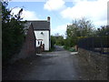
Cow Pasture Lane
Heading west near Kirkby Cross.
Image: © JThomas
Taken: 18 Apr 2014
0.03 miles
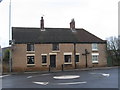
2
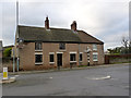
2 and 6 Church Street, Kirkby-in-Ashfield
Originally a farmhouse but now two separate dwellings. Built c.1775 and Listed Grade II. The section with the lighter, hipped, roof is a 20th century extension.
Image: © Alan Murray-Rust
Taken: 30 Nov 2014
0.03 miles
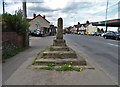
3
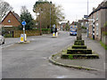
Medieval Cross, Kirkby-in-Ashfield
At the junction of Church Street with Chapel Street.
Like many similar crosses it has lost the upper part of the cross itself. Listed Grade II and also Scheduled Monument. The Listing description dates the cross to the 14th century; the Monument description declines to attribute a date.
Image: © Alan Murray-Rust
Taken: 30 Nov 2014
0.03 miles
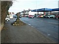
4
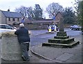
Vehicle Spill at Kirkby Market Cross
Just a moment earlier a tractor and trailer had sped across the nearby mini-roundabout before careering around the bend and losing this bale. The passer-by here has just rolled it off the main road and is reporting the incident. A dangerous bit of driving to say the least.
Image: © Jonathan Clitheroe
Taken: 5 Jan 2019
0.03 miles
5
Medieval cross by Sutton Road, Kirkby-in-Ashfield
For detailed information about this well-preserved village cross, go here:- http://www.ournottinghamshire.org.uk/page/kirkby_cross
Image: © Neil Theasby
Taken: 1 May 2018
0.04 miles
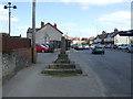
6
Kirkby Cross, Kirkby in Ashfield
The old market cross. Originally at the centre of the settlement, it is now in a conservation area (Old Kirkby), while the commercial centre of Kirkby is at what is strictly called East Kirkby (Image). "Strictly" as in the map says it, but the locals don't - vernacular geography in reverse?
Image: © Katy Walters
Taken: 4 Dec 2005
0.04 miles
7
Kirkby Cross
Junction of Church Street, Chapel Street.
Image: © JThomas
Taken: 18 Apr 2014
0.04 miles
8
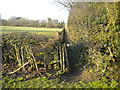
Footpath to Cow Pasture Lane, Kirkby
A very narrow path, hemmed in between a fence and a tall hedge, heading north from the entrance to Titchfield Park.
Image: © Richard Vince
Taken: 24 Feb 2018
0.04 miles
9
Kirkby-in-Ashfield - cottages at Kirkby Cross
The cross depicted at Image (and after which Kirkby Cross is named) is just to the north of these cottages. The cross was originally sited where the mini-roundabout now is.
Image: © Dave Bevis
Taken: 8 Jan 2009
0.04 miles
10
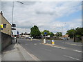
B6018 Church Street/B6020 Chapel Street roundabout
Viewed from Church Street.
Image: © John Topping
Taken: 25 Jun 2013
0.05 miles