IMAGES TAKEN NEAR TO
Pennine Drive, NOTTINGHAM, NG17 8LL
Introduction
This page details the photographs taken nearby to Pennine Drive, NG17 8LL by members of the Geograph project.
The Geograph project started in 2005 with the aim of publishing, organising and preserving representative images for every square kilometre of Great Britain, Ireland and the Isle of Man.

There are currently over 7.5m images from over14,400 individuals and you can help contribute to the project by visiting https://www.geograph.org.uk
Image Map
Images are licensed for reuse under creativecommons.org/licenses/by-sa/2.0
Notes
- Clicking on the map will re-center to the selected point.
- The higher the marker number, the further away the image location is from the centre of the postcode.
Image Listing (68 Images Found)
Images are licensed for reuse under creativecommons.org/licenses/by-sa/2.0
Image
Details
Distance
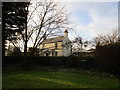
1
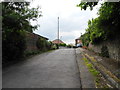
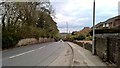
Pennine Drive, Bentinck Town
Viewed from Church Hill (B6018).
Image: © John Topping
Taken: 25 Jun 2013
0.02 miles
2
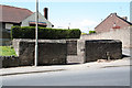
The Pinfold
Kirkby-in-Ashfield pinfold on Church Hill, built c1740
Image: © Richard Croft
Taken: 4 May 2010
0.05 miles
3
Pinfold, Church Hill, Kirkby-in-Ashfield
Dating from c.1740, restored late 20th century. Listed Grade II.
Image: © Alan Murray-Rust
Taken: 5 Dec 2014
0.06 miles
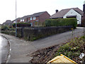
4
Towards Castle Hill, Kirkby in Ashfield
St Wilfrid's Church is on the top of the hill, just over into Image
Image: © Katy Walters
Taken: 4 Dec 2005
0.06 miles
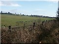
6
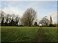
Castle Hill, Kirkby in Ashfield
The defensive possibilities of this site with wide views to the south and east is apparent, The site though is much degraded https://historicengland.org.uk/listing/the-list/list-entry/1009298
Image: © Jonathan Thacker
Taken: 29 Dec 2019
0.07 miles
7
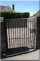
The Pinfold
Kirkby-in-Ashfield pinfold http://www.geograph.org.uk/photo/1845256 on Church Hill, built c1740
Image: © Richard Croft
Taken: 4 May 2010
0.07 miles
8
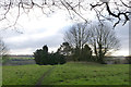
Castle Hill, Kirkby-in-Ashfield
This flat rectangular area to south of the church is the site of a medieval fortified manor, rather than a castle. The manor was occupied from the 14th century to at least the late 15th century. Although robbed of all stonework above ground, foundations will have survived as the site has remained relatively undisturbed. It is a Scheduled Monument.
Image: © Alan Murray-Rust
Taken: 30 Nov 2014
0.08 miles
10
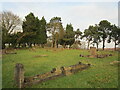
Cemetery, Castle Hill, Kirkby in Ashfield
Image: © Jonathan Thacker
Taken: 29 Dec 2019
0.08 miles