IMAGES TAKEN NEAR TO
Lawrence Avenue, NOTTINGHAM, NG17 8JW
Introduction
This page details the photographs taken nearby to Lawrence Avenue, NG17 8JW by members of the Geograph project.
The Geograph project started in 2005 with the aim of publishing, organising and preserving representative images for every square kilometre of Great Britain, Ireland and the Isle of Man.

There are currently over 7.5m images from over14,400 individuals and you can help contribute to the project by visiting https://www.geograph.org.uk
Image Map
Images are licensed for reuse under creativecommons.org/licenses/by-sa/2.0
Notes
- Clicking on the map will re-center to the selected point.
- The higher the marker number, the further away the image location is from the centre of the postcode.
Image Listing (48 Images Found)
Images are licensed for reuse under creativecommons.org/licenses/by-sa/2.0
Image
Details
Distance
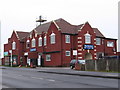
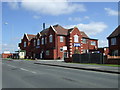
2
The Bentinck
A miners welfare club, though it states that membership is open to all.
Image: © Bill Boaden
Taken: 26 Nov 2021
0.16 miles
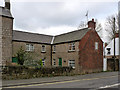
3
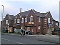
The Bentinck on Sutton Road
Miners Welfare Club in Kirkby-in-Ashfield.
Image: © Jonathan Clitheroe
Taken: 5 Jan 2019
0.16 miles
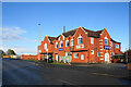
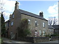
4
The Bentinck, Sutton Road
Formerly the Kirkby Bentinck Miners' Welfare Institute. The name Bentinck comes from the name of the local colliery.
Image: © Alan Murray-Rust
Taken: 30 Nov 2014
0.16 miles
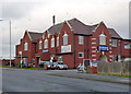
5
The Bentinck pub
Former Miners Welfare on Sutton Road.
Image: © JThomas
Taken: 18 Apr 2014
0.16 miles
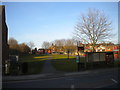
7

Green space by The Hill
This appears to be a buffer left between two housing estates. The bus stop is named after Greenwood Drive.
Image: © Bill Boaden
Taken: 26 Nov 2021
0.17 miles
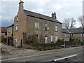
8
Smithy's Cottage, Chapel Street
Associated with Chapel Street Farm. There is no mapped evidence that there was a smithy here.
Image: © Alan Murray-Rust
Taken: 30 Nov 2014
0.17 miles
10
Footpath north from Chapel Street, Kirkby
Approximately following the line of the cutting (now filled in) that was occupied by the Mansfield Railway (a line that linked the Great Central Railway's lines in Kirkby and Clipstone).
Image: © Richard Vince
Taken: 24 Feb 2018
0.17 miles