IMAGES TAKEN NEAR TO
Cedar Avenue, NOTTINGHAM, NG17 8BD
Introduction
This page details the photographs taken nearby to Cedar Avenue, NG17 8BD by members of the Geograph project.
The Geograph project started in 2005 with the aim of publishing, organising and preserving representative images for every square kilometre of Great Britain, Ireland and the Isle of Man.

There are currently over 7.5m images from over14,400 individuals and you can help contribute to the project by visiting https://www.geograph.org.uk
Image Map
Images are licensed for reuse under creativecommons.org/licenses/by-sa/2.0
Notes
- Clicking on the map will re-center to the selected point.
- The higher the marker number, the further away the image location is from the centre of the postcode.
Image Listing (7 Images Found)
Images are licensed for reuse under creativecommons.org/licenses/by-sa/2.0
Image
Details
Distance
1
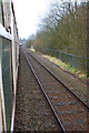
Pathfinder Tours charter train approaching Kirkby in Ashfield
Image: © Roger Templeman
Taken: 26 Mar 2016
0.12 miles
2
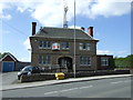
Post Office and newsagents on Victoria Road
Image: © JThomas
Taken: 18 Apr 2014
0.19 miles
3
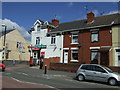
Victoria Road Post Office, Kirkby in Ashfield
On the corner with Hampden Street.
Image: © John Topping
Taken: 25 Jun 2013
0.20 miles
4
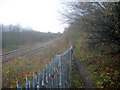
Fence by the railway
The public footpath tracks north to Kirkby-in-Ashfield alongside the railway and is separated by a modern metal fence with sharp points on the top to prevent access. The fence provides a good support for a tangle of Black Bryony, with its clusters of red berries.
Image: © Trevor Rickard
Taken: 28 Nov 2009
0.20 miles
5
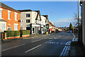
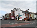
Victoria Road
The B6020 heading for the centre of Kirkby-in-Ashfield.
Image: © Bill Boaden
Taken: 26 Nov 2021
0.23 miles
6

Victoria Road B6020, Kirkby in Ashfield
Park Street/Wheatley Avenue junction.
Image: © John Topping
Taken: 25 Jun 2013
0.23 miles