IMAGES TAKEN NEAR TO
Derby Road, NOTTINGHAM, NG17 7RF
Introduction
This page details the photographs taken nearby to Derby Road, NG17 7RF by members of the Geograph project.
The Geograph project started in 2005 with the aim of publishing, organising and preserving representative images for every square kilometre of Great Britain, Ireland and the Isle of Man.

There are currently over 7.5m images from over14,400 individuals and you can help contribute to the project by visiting https://www.geograph.org.uk
Image Map
Images are licensed for reuse under creativecommons.org/licenses/by-sa/2.0
Notes
- Clicking on the map will re-center to the selected point.
- The higher the marker number, the further away the image location is from the centre of the postcode.
Image Listing (3 Images Found)
Images are licensed for reuse under creativecommons.org/licenses/by-sa/2.0
Image
Details
Distance

2
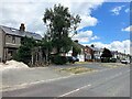
Dwellings on Blidworth Road
This row of properties mark the eastern extremity of Kirky-in-Ashfield.
Image: © Jonathan Clitheroe
Taken: 15 Jul 2022
0.14 miles
3
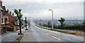
Westward on B6020 approaching Kirkby-in-Ashfield
'Might be anywhere' in semi-industrial Middle England: a typical main road scene in Nottinghamshire - between the showers.
Image: © Ben Brooksbank
Taken: 12 Jul 1963
0.20 miles