IMAGES TAKEN NEAR TO
Derby Road, NOTTINGHAM, NG17 7QR
Introduction
This page details the photographs taken nearby to Derby Road, NG17 7QR by members of the Geograph project.
The Geograph project started in 2005 with the aim of publishing, organising and preserving representative images for every square kilometre of Great Britain, Ireland and the Isle of Man.

There are currently over 7.5m images from over14,400 individuals and you can help contribute to the project by visiting https://www.geograph.org.uk
Image Map
Images are licensed for reuse under creativecommons.org/licenses/by-sa/2.0
Notes
- Clicking on the map will re-center to the selected point.
- The higher the marker number, the further away the image location is from the centre of the postcode.
Image Listing (7 Images Found)
Images are licensed for reuse under creativecommons.org/licenses/by-sa/2.0
Image
Details
Distance
1

Club house at Notts Golf Club, Hollinwell
Image: © Antony Dixon
Taken: 27 Jul 2016
0.00 miles
2

Golf Club House
Club house at Notts Golf Course, Hollinwell.
Image: © Antony Dixon
Taken: 27 Jul 2016
0.01 miles
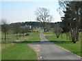
3

Golf Course at Notts Golf Club, Hollinwell
Image: © Antony Dixon
Taken: 27 Jul 2016
0.04 miles
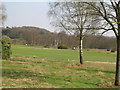
6

Notts Golf Club and the Joan Slut Plantation
When I see something with a picturesque name, I just have to photograph it.
Image: © Antony Dixon
Taken: 27 Jul 2016
0.17 miles
