IMAGES TAKEN NEAR TO
Morven Road, NOTTINGHAM, NG17 7BX
Introduction
This page details the photographs taken nearby to Morven Road, NG17 7BX by members of the Geograph project.
The Geograph project started in 2005 with the aim of publishing, organising and preserving representative images for every square kilometre of Great Britain, Ireland and the Isle of Man.

There are currently over 7.5m images from over14,400 individuals and you can help contribute to the project by visiting https://www.geograph.org.uk
Image Map
Images are licensed for reuse under creativecommons.org/licenses/by-sa/2.0
Notes
- Clicking on the map will re-center to the selected point.
- The higher the marker number, the further away the image location is from the centre of the postcode.
Image Listing (30 Images Found)
Images are licensed for reuse under creativecommons.org/licenses/by-sa/2.0
Image
Details
Distance
1
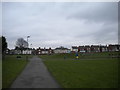
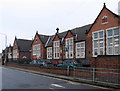
Morven Park, Kirkby
Seen from School Street.
Image: © Richard Vince
Taken: 2 Dec 2017
0.05 miles
2
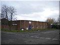
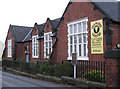
Kirkby Catholic Social Club
On the corner of Sherwood Street (left) and School Street, attached to Our Lady Help of Christians Roman Catholic church.
Image: © Richard Vince
Taken: 2 Dec 2017
0.06 miles
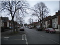
6
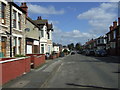
Clumber Street, Kirkby in Ashfield
Looking north.
Image: © JThomas
Taken: 18 Apr 2014
0.16 miles
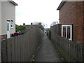
7
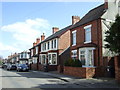
Houses on Clumber Street, Kirkby in Ashfield
Image: © JThomas
Taken: 18 Apr 2014
0.16 miles
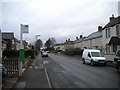
10
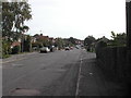
Diamond Avenue, Kirkby
Looking towards the A611 from the edge of the town centre.
Image: © Richard Vince
Taken: 2 Dec 2017
0.20 miles