IMAGES TAKEN NEAR TO
Coxmoor Road, SUTTON-IN-ASHFIELD, NG17 5LF
Introduction
This page details the photographs taken nearby to Coxmoor Road, NG17 5LF by members of the Geograph project.
The Geograph project started in 2005 with the aim of publishing, organising and preserving representative images for every square kilometre of Great Britain, Ireland and the Isle of Man.

There are currently over 7.5m images from over14,400 individuals and you can help contribute to the project by visiting https://www.geograph.org.uk
Image Map
Images are licensed for reuse under creativecommons.org/licenses/by-sa/2.0
Notes
- Clicking on the map will re-center to the selected point.
- The higher the marker number, the further away the image location is from the centre of the postcode.
Image Listing (4 Images Found)
Images are licensed for reuse under creativecommons.org/licenses/by-sa/2.0
Image
Details
Distance
1
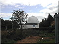
Sherwood Observatory
On a hill just yards off the Coxmoor Road and next to Coxmoor Golf Course. It is at certain times open to the public.
Image: © Tom Courtney
Taken: 29 Sep 2005
0.03 miles
2
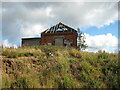
Derelict building close to Sherwood Observatory
Image: © Jonathan Thacker
Taken: 5 Oct 2020
0.05 miles
3
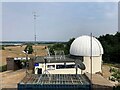
Sherwood Observatory
Operated by Mansfield and Sutton Astrological Society and home to a 61 centimetre Newtonian telescope. The observatory hosts occasional open days and run basic accredited astronomy courses in addition to group visits by arrangement. This picture was taken from a nearby derelict structure which stands at a slightly higher elevation to the observatory itself.
Image: © Jonathan Clitheroe
Taken: 20 Jul 2022
0.06 miles
4
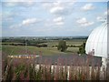
Sherwood Observatory
Sherwood Observatory, looking towards Mansfield, with the spire of St. John's Church visible in the centre of the photo.
Image: © Antony Dixon
Taken: 2 Sep 2011
0.06 miles