IMAGES TAKEN NEAR TO
Cauldwell Road, SUTTON-IN-ASHFIELD, NG17 5LB
Introduction
This page details the photographs taken nearby to Cauldwell Road, NG17 5LB by members of the Geograph project.
The Geograph project started in 2005 with the aim of publishing, organising and preserving representative images for every square kilometre of Great Britain, Ireland and the Isle of Man.

There are currently over 7.5m images from over14,400 individuals and you can help contribute to the project by visiting https://www.geograph.org.uk
Image Map
Images are licensed for reuse under creativecommons.org/licenses/by-sa/2.0
Notes
- Clicking on the map will re-center to the selected point.
- The higher the marker number, the further away the image location is from the centre of the postcode.
Image Listing (3 Images Found)
Images are licensed for reuse under creativecommons.org/licenses/by-sa/2.0
Image
Details
Distance
1
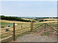
Countryside and Distribution Centre near Sutton
This is EMA2 - a new and highly automised Amazon Fulfillment Centre which opened in late 2020. Surrounded by prime countryside it's pictured from a field entrance off the B6139 Coxmoor Road at the extreme south west corner of the grid square.
Image: © Jonathan Clitheroe
Taken: 20 Jul 2022
0.18 miles
3
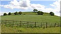
Hamilton Hill
In a largely flat landscape, this modest sized hill can be seen for miles around. It is farmland, but the old country lanes are rapidly being transformed into major new roads and may perhaps soon be hemmed in by industry.
It is in the north west corner of square SK5258 and overlaps a little into surrounding squares.
Image: © Peter Kochut
Taken: 23 May 2005
0.19 miles