IMAGES TAKEN NEAR TO
Willow Gardens, SUTTON-IN-ASHFIELD, NG17 5JF
Introduction
This page details the photographs taken nearby to Willow Gardens, NG17 5JF by members of the Geograph project.
The Geograph project started in 2005 with the aim of publishing, organising and preserving representative images for every square kilometre of Great Britain, Ireland and the Isle of Man.

There are currently over 7.5m images from over14,400 individuals and you can help contribute to the project by visiting https://www.geograph.org.uk
Image Map
Images are licensed for reuse under creativecommons.org/licenses/by-sa/2.0
Notes
- Clicking on the map will re-center to the selected point.
- The higher the marker number, the further away the image location is from the centre of the postcode.
Image Listing (8 Images Found)
Images are licensed for reuse under creativecommons.org/licenses/by-sa/2.0
Image
Details
Distance
2
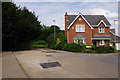
Sheepwash Lane, Sutton in Ashfield
By this modern house Sheepwash Lane becomes a footpath giving access to Lucknow Drive under King's Mill Road, the modern A38.
Image: © Stephen McKay
Taken: 23 Jul 2016
0.10 miles
3
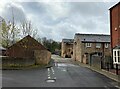
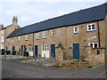
Site of Dobson's Mill at Samuel Unwin Court
One of the world's earliest powered mills was built here in 1740 and some of the early buildings associated with the trade can be seen here.
Image: © Jonathan Clitheroe
Taken: 13 Apr 2022
0.16 miles
4
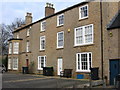
Sutton-in-Ashfield - Dobson's Mill House
According to a plaque on the access road to this house, Dobson's Mill was named in commemoration of the original mill built by Samuel Unwin in 1740 and one of the first cotton mills to use powered machinery. Samuel Unwin died in 1841 and, after a succession of owners, the site was sold in 1920 to William Francis Dobson and Edward Josiah Allsop. The Dobsons retained ownership until its closure in the early 1980's.
Image: © Dave Bevis
Taken: 20 Feb 2009
0.19 miles
6
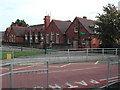
Hillocks Primary School
located on Coxmore Road, Sutton Forest side
Image: © Tom Courtney
Taken: 9 Oct 2005
0.23 miles
7

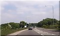
Robin Hood Line, Sutton Junction
An East Midlands Trains service heads over the level crossing at Sutton Junction on its way to Nottingham. The line was reopened to passengers in stages during the 1990s having originally closed as a victim of the Beeching cuts in 1964. The route was always important for coal, but this traffic has now all but ceased with the demise of deep mining in the area, leaving only the passenger trains. Just to the south of the crossing was the site of Sutton Junction station where once the 'Penny Emma' service gave a link to the town centre. When the line was reopened it was decided not to rebuild the station here but to site a new one - Sutton Parkway - further south.
Image: © Stephen McKay
Taken: 23 Jul 2016
0.25 miles
8

Station Road, Sutton in Ashfield
Despite the road's name, anybody expecting to find Sutton's station here will be disappointed. In fact, until 1964 Sutton Junction station was located just to the south of the level crossing; as the name implies it was a junction with, until 1951, a short branch to the centre of Sutton. The branch passenger service was affectionately known as the 'Penny Emma'. When the line reopened to passengers in 1995 it was decided not to reopen a station at this location but instead Sutton Parkway was opened further to the south
Image: © Stephen McKay
Taken: 23 Jul 2016
0.25 miles