IMAGES TAKEN NEAR TO
Kirkby Folly Road, SUTTON-IN-ASHFIELD, NG17 5HP
Introduction
This page details the photographs taken nearby to Kirkby Folly Road, NG17 5HP by members of the Geograph project.
The Geograph project started in 2005 with the aim of publishing, organising and preserving representative images for every square kilometre of Great Britain, Ireland and the Isle of Man.

There are currently over 7.5m images from over14,400 individuals and you can help contribute to the project by visiting https://www.geograph.org.uk
Image Map
Images are licensed for reuse under creativecommons.org/licenses/by-sa/2.0
Notes
- Clicking on the map will re-center to the selected point.
- The higher the marker number, the further away the image location is from the centre of the postcode.
Image Listing (27 Images Found)
Images are licensed for reuse under creativecommons.org/licenses/by-sa/2.0
Image
Details
Distance
1
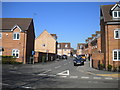
Beginning of Cornmill Road, Sutton Junction
From this junction with Kirkby Folly Road, Cornmill Road twists and turns its way vaguely south west in the sinuous manner of contemporaneous developments.
Image: © Richard Vince
Taken: 5 May 2018
0.06 miles
2
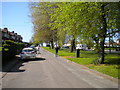
Service road alongside Kirkby Folly Road, Sutton Junction
Looking towards Kirkby.
Image: © Richard Vince
Taken: 5 May 2018
0.09 miles
3
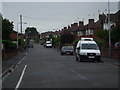
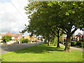
Farndon Road, Sutton in Ashfield, Notts.
Image: © nick macneill
Taken: 21 Jul 2009
0.10 miles
4
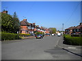
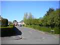
Northern half of Farndon Road, Sutton Junction
Seen from the junction with Sotheby Avenue.
Image: © Richard Vince
Taken: 5 May 2018
0.12 miles
5
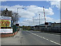
Level crossing on Station Road, Sutton in Ashfield
Heading east.
Image: © JThomas
Taken: 18 Apr 2014
0.12 miles
6

Station Road, Sutton in Ashfield
Despite the road's name, anybody expecting to find Sutton's station here will be disappointed. In fact, until 1964 Sutton Junction station was located just to the south of the level crossing; as the name implies it was a junction with, until 1951, a short branch to the centre of Sutton. The branch passenger service was affectionately known as the 'Penny Emma'. When the line reopened to passengers in 1995 it was decided not to reopen a station at this location but instead Sutton Parkway was opened further to the south
Image: © Stephen McKay
Taken: 23 Jul 2016
0.12 miles
8

Robin Hood Line, Sutton Junction
An East Midlands Trains service heads over the level crossing at Sutton Junction on its way to Nottingham. The line was reopened to passengers in stages during the 1990s having originally closed as a victim of the Beeching cuts in 1964. The route was always important for coal, but this traffic has now all but ceased with the demise of deep mining in the area, leaving only the passenger trains. Just to the south of the crossing was the site of Sutton Junction station where once the 'Penny Emma' service gave a link to the town centre. When the line was reopened it was decided not to rebuild the station here but to site a new one - Sutton Parkway - further south.
Image: © Stephen McKay
Taken: 23 Jul 2016
0.13 miles
9
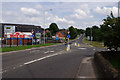
Newark Road, Sutton in Ashfield
Looking east from the Sutton Junction level crossing along the B6022 where it meets the B6021.
Image: © Stephen McKay
Taken: 23 Jul 2016
0.13 miles
10
Leabrooks Avenue, Sutton Junction
Seen from Farndon Road.
Image: © Richard Vince
Taken: 5 May 2018
0.13 miles