IMAGES TAKEN NEAR TO
Pepper Street, SUTTON-IN-ASHFIELD, NG17 5GE
Introduction
This page details the photographs taken nearby to Pepper Street, NG17 5GE by members of the Geograph project.
The Geograph project started in 2005 with the aim of publishing, organising and preserving representative images for every square kilometre of Great Britain, Ireland and the Isle of Man.

There are currently over 7.5m images from over14,400 individuals and you can help contribute to the project by visiting https://www.geograph.org.uk
Image Map
Images are licensed for reuse under creativecommons.org/licenses/by-sa/2.0
Notes
- Clicking on the map will re-center to the selected point.
- The higher the marker number, the further away the image location is from the centre of the postcode.
Image Listing (17 Images Found)
Images are licensed for reuse under creativecommons.org/licenses/by-sa/2.0
Image
Details
Distance
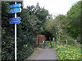
2
Station Road, Sutton in Ashfield (B6022)
Heading east.
Image: © JThomas
Taken: 18 Apr 2014
0.11 miles
3
Station Road Post Office, Sutton in Ashfield
Image: © JThomas
Taken: 18 Apr 2014
0.12 miles
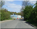
4
Sheepwash Lane, Sutton in Ashfield
By this modern house Sheepwash Lane becomes a footpath giving access to Lucknow Drive under King's Mill Road, the modern A38.
Image: © Stephen McKay
Taken: 23 Jul 2016
0.12 miles
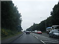
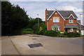
6
Kings Mill Road East (A38)
Heading north east towards Mansfield.
Image: © JThomas
Taken: 18 Apr 2014
0.15 miles
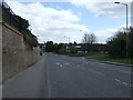
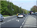
7

Kings Mill Road East
Approaching Station Road traffic lights.
Image: © J.Hannan-Briggs
Taken: 23 Jun 2014
0.15 miles
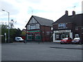
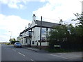
8
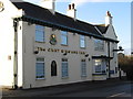
Sutton-in-Ashfield - The Cart and Horse Inn
On Station Road.
Image: © Dave Bevis
Taken: 23 Nov 2010
0.17 miles
9
The Cart & Horse Inn
On Station Road, Sutton in Ashfield.
Image: © JThomas
Taken: 18 Apr 2014
0.17 miles