IMAGES TAKEN NEAR TO
Clare Road, SUTTON-IN-ASHFIELD, NG17 5BB
Introduction
This page details the photographs taken nearby to Clare Road, NG17 5BB by members of the Geograph project.
The Geograph project started in 2005 with the aim of publishing, organising and preserving representative images for every square kilometre of Great Britain, Ireland and the Isle of Man.

There are currently over 7.5m images from over14,400 individuals and you can help contribute to the project by visiting https://www.geograph.org.uk
Image Map
Images are licensed for reuse under creativecommons.org/licenses/by-sa/2.0
Notes
- Clicking on the map will re-center to the selected point.
- The higher the marker number, the further away the image location is from the centre of the postcode.
Image Listing (15 Images Found)
Images are licensed for reuse under creativecommons.org/licenses/by-sa/2.0
Image
Details
Distance
1
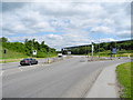
A38 Kings Mill Road East, Sutton in Ashfield (1)
Police investigating, after a road traffic accident.
Image: © John Topping
Taken: 25 Jun 2013
0.09 miles
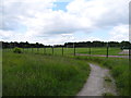
2
Footpath crossing of A38
Path leads to the primary school to the left
Image: © John Firth
Taken: 9 Jun 2013
0.10 miles
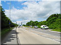
3
A38 Kings Mill Road East, Sutton in Ashfield (2)
Approaching the A38/B6018 junction from the east.
Image: © John Topping
Taken: 25 Jun 2013
0.17 miles
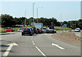
5
A38/B6021 junction, Sutton in Ashfield
Kings Mill Road East/Penny Emma Way.
Image: © John Topping
Taken: 25 Jun 2013
0.20 miles
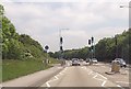
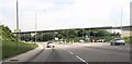
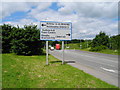
6
A38 approaching B6021 junction
Turn off for Kirkby-in-Ashfield and Sutton Parkway Station.
Image: © J.Hannan-Briggs
Taken: 23 Jun 2014
0.21 miles
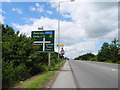
8
Junction of road to Sutton Park station
From A38
Image: © John Firth
Taken: 9 Jun 2013
0.22 miles
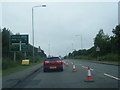
9
Approaching Kings Mill Road East (A38)
Heading northwest to the junction on B6021 Penny Emma Way.
Image: © John Topping
Taken: 25 Jun 2013
0.22 miles
10
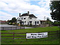
Fountain Bridge, Sutton in Ashfield (1)
Public House off Kirkby Road B6018.
Image: © John Topping
Taken: 25 Jun 2013
0.22 miles