IMAGES TAKEN NEAR TO
The Twitchell, SUTTON-IN-ASHFIELD, NG17 5AW
Introduction
This page details the photographs taken nearby to The Twitchell, NG17 5AW by members of the Geograph project.
The Geograph project started in 2005 with the aim of publishing, organising and preserving representative images for every square kilometre of Great Britain, Ireland and the Isle of Man.

There are currently over 7.5m images from over14,400 individuals and you can help contribute to the project by visiting https://www.geograph.org.uk
Image Map
Images are licensed for reuse under creativecommons.org/licenses/by-sa/2.0
Notes
- Clicking on the map will re-center to the selected point.
- The higher the marker number, the further away the image location is from the centre of the postcode.
Image Listing (3 Images Found)
Images are licensed for reuse under creativecommons.org/licenses/by-sa/2.0
Image
Details
Distance
1

Sunshine on the terrace
Looking along Silk Street.
Image: © Alan Murray-Rust
Taken: 5 Dec 2014
0.23 miles
2
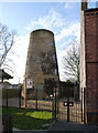
Lindley's Windmill, Sutton-in-Ashfield
Stone-built tower mill, built c.1823 by James Lindley to replace an earlier post mill destroyed by a gale in 1818. It was worked until 1895 after which it gradually became ruinous http://www.geograph.org.uk/photo/4274087. The structure has been consolidated in recent years and re-roofed, and the intention is to create educational displays. It can be visited by appointment, but when I turned up, the caretaker appeared from an adjacent house and was pleased to show me around. Listed Grade II.
Image: © Alan Murray-Rust
Taken: 5 Dec 2014
0.25 miles
3
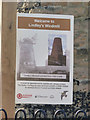
Welcome to Lindley's Windmill, Sutton-in-Ashfield
Information board with an old picture of the mill with some features still remaining. It clearly had 4 sails and a fantail cap. There is a second information board at the site detailing the location of all 9 former mills - wind and water - in Sutton-in-Ashfield. This is the only survivor.
Image: © Alan Murray-Rust
Taken: 5 Dec 2014
0.25 miles