IMAGES TAKEN NEAR TO
Deepdale Park, SUTTON-IN-ASHFIELD, NG17 4NT
Introduction
This page details the photographs taken nearby to Deepdale Park, NG17 4NT by members of the Geograph project.
The Geograph project started in 2005 with the aim of publishing, organising and preserving representative images for every square kilometre of Great Britain, Ireland and the Isle of Man.

There are currently over 7.5m images from over14,400 individuals and you can help contribute to the project by visiting https://www.geograph.org.uk
Image Map
Images are licensed for reuse under creativecommons.org/licenses/by-sa/2.0
Notes
- Clicking on the map will re-center to the selected point.
- The higher the marker number, the further away the image location is from the centre of the postcode.
Image Listing (17 Images Found)
Images are licensed for reuse under creativecommons.org/licenses/by-sa/2.0
Image
Details
Distance
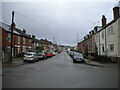
2
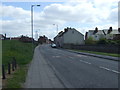
Stoneyford Road (B6028)
Heading south east.
Image: © JThomas
Taken: 18 Apr 2014
0.18 miles
3
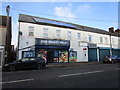
Mini Market Polo, Mansfield Road, Sutton in Ashfield
Image: © Jonathan Thacker
Taken: 12 Jan 2020
0.19 miles
4
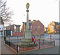
Sutton-in-Ashfield - War Memorial on Downing Street
This is one of two war memorials in Sutton-in-Ashfield. This one was originally sited in the churchyard of St Michael and All Angels Church on Outram Street (see Image). When that church became redundant, the memorial was moved to its current location in the apex formed by the junction of Downing Street with Mansfield Road. It displays the names of the casualties of the 1914-18 war who lived within the area of the St Michael and All Angels Church parish.
The other war memorial is in Sutton-in-Ashfield Cemetery (next to St Mary's Church on Lammas Road). For a photo of this, please see Alan Murray-Rust's Image This memorial shows the casualties from both the 1914-18 and 1939-45 wars.
For more details of both war memorials, please see http://www.oldnotts.co.uk/sutton/memorial/index.htm .
Image: © Dave Bevis
Taken: 27 Dec 2015
0.21 miles
5
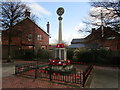
War Memorial, New Cross, Sutton in Ashfield
Commemorates the fallen of WW1 https://historicengland.org.uk/listing/the-list/list-entry/1431444
Image: © Jonathan Thacker
Taken: 12 Jan 2020
0.21 miles
6
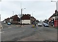
Busy Crossroads in Sutton in Ashfield
Image: © Jonathan Clitheroe
Taken: 22 Feb 2020
0.22 miles
7

Sutton-in-Ashfield - New Cross
For an alternative view (and colour scheme), please see Image
Image: © Dave Bevis
Taken: 1 Jan 2011
0.22 miles
8
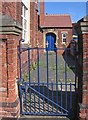
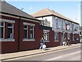
Sutton-in-Ashfield - Forest Glade Primary School
Boys entrance to school from Mansfield Road.
Image: © Dave Bevis
Taken: 11 Jun 2015
0.22 miles
9
South end of Forest Road, Sutton
Looking towards Skegby from Dalestorth Road.
Image: © Richard Vince
Taken: 12 Dec 2020
0.22 miles