IMAGES TAKEN NEAR TO
NG17 3NR
Introduction
This page details the photographs taken nearby to NG17 3NR by members of the Geograph project.
The Geograph project started in 2005 with the aim of publishing, organising and preserving representative images for every square kilometre of Great Britain, Ireland and the Isle of Man.

There are currently over 7.5m images from over14,400 individuals and you can help contribute to the project by visiting https://www.geograph.org.uk
Image Map
Images are licensed for reuse under creativecommons.org/licenses/by-sa/2.0
Notes
- Clicking on the map will re-center to the selected point.
- The higher the marker number, the further away the image location is from the centre of the postcode.
Image Listing (8 Images Found)
Images are licensed for reuse under creativecommons.org/licenses/by-sa/2.0
Image
Details
Distance
1
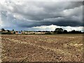
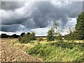
Ploughed Field off Beck Lane
Pictured from a public footpath which leads west towards Skegby. A new housing development is taking shape in the middle distance further expanding the Mansfield conurbation to the north west. The foreboding skyline on this day promised heavy thundery showers.
Image: © Jonathan Clitheroe
Taken: 26 Aug 2023
0.09 miles
2
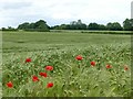
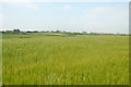
Poppies at the edge of a field of barley
Image: © Graham Hogg
Taken: 12 Jun 2017
0.11 miles
3
On a path towards Mansfield Lane
In a barley field, east of Skegby.
Image: © Peter Barr
Taken: 8 Jul 2012
0.13 miles
4
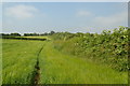
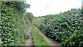
Footpath, not clearly to be seen
Through a barley field, straight ahead.
Image: © Peter Barr
Taken: 8 Jul 2012
0.15 miles
7
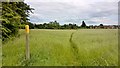
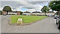
Waymarker and path between Skegby and Mansfield
Image: © Chris Morgan
Taken: 12 Jun 2017
0.20 miles