IMAGES TAKEN NEAR TO
NG17 3NN
Introduction
This page details the photographs taken nearby to NG17 3NN by members of the Geograph project.
The Geograph project started in 2005 with the aim of publishing, organising and preserving representative images for every square kilometre of Great Britain, Ireland and the Isle of Man.

There are currently over 7.5m images from over14,400 individuals and you can help contribute to the project by visiting https://www.geograph.org.uk
Image Map
Images are licensed for reuse under creativecommons.org/licenses/by-sa/2.0
Notes
- Clicking on the map will re-center to the selected point.
- The higher the marker number, the further away the image location is from the centre of the postcode.
Image Listing (13 Images Found)
Images are licensed for reuse under creativecommons.org/licenses/by-sa/2.0
Image
Details
Distance
1
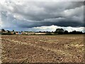
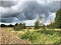
Ploughed Field off Beck Lane
Pictured from a public footpath which leads west towards Skegby. A new housing development is taking shape in the middle distance further expanding the Mansfield conurbation to the north west. The foreboding skyline on this day promised heavy thundery showers.
Image: © Jonathan Clitheroe
Taken: 26 Aug 2023
0.09 miles
2
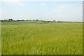
Footpath, not clearly to be seen
Through a barley field, straight ahead.
Image: © Peter Barr
Taken: 8 Jul 2012
0.17 miles
3
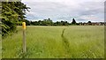
Waymarker and path between Skegby and Mansfield
Image: © Chris Morgan
Taken: 12 Jun 2017
0.17 miles
7
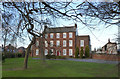
Dalestorth House, Skegby
Late 18th century Georgian style house of 3 storeys, 5 bays with wings. Listed Grade II. Built around 1770 by the Rector of Teversal on the site of the former Cock Inn.
The house was enlarged in the early 19th century before being sold to John Miller, a local farmer and maltster. His nephew then converted the house into a young ladies boarding school, a role which continued until the opening of the Girls Grammar School in Mansfield. The house was then occupied by various descendants until around 1974.
The new owners from 1976 created a garden centre in the grounds, and eventually converted the house to a bed and breakfast style hotel. Historic details courtesy of the website, http://www.dalestorthguesthouse.com/90300/info.php?p=1 .
Image: © Alan Murray-Rust
Taken: 5 Dec 2014
0.20 miles
8
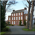
Dalestorth House, Skegby
Late 18th century Georgian style house of 3 storeys, 5 bays with wings. Listed Grade II. Built around 1770 by the Rector of Teversal on the site of the former Cock Inn.
The house was enlarged in the early 19th century before being sold to John Miller, a local farmer and maltster. His nephew then converted the house into a young ladies boarding school, a role which continued until the opening of the Girls Grammar School in Mansfield. The house was then occupied by various descendants until around 1974.
The new owners from 1976 created a garden centre in the grounds, and eventually converted the house to a bed and breakfast style hotel. Historic details courtesy of the website, http://www.dalestorthguesthouse.com/90300/info.php?p=1 .
Image: © Alan Murray-Rust
Taken: 5 Dec 2014
0.20 miles
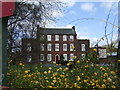
9
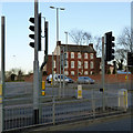
Crossroads with Dalestorth House, Skegby
Visually this fine Georgian house is not well served by the extensive road junction created with the opening of Kings Mill Road as part of the Mansfield ring road. See http://www.geograph.org.uk/photo/4274104 for details of the house.
Image: © Alan Murray-Rust
Taken: 5 Dec 2014
0.22 miles
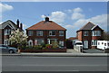
10
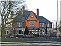
Skegby - Fox & Crown
Pub on Mansfield Road.
Image: © Dave Bevis
Taken: 24 Feb 2016
0.24 miles