IMAGES TAKEN NEAR TO
Brewers Corner, SUTTON-IN-ASHFIELD, NG17 3LS
Introduction
This page details the photographs taken nearby to Brewers Corner, NG17 3LS by members of the Geograph project.
The Geograph project started in 2005 with the aim of publishing, organising and preserving representative images for every square kilometre of Great Britain, Ireland and the Isle of Man.

There are currently over 7.5m images from over14,400 individuals and you can help contribute to the project by visiting https://www.geograph.org.uk
Image Map
Images are licensed for reuse under creativecommons.org/licenses/by-sa/2.0
Notes
- Clicking on the map will re-center to the selected point.
- The higher the marker number, the further away the image location is from the centre of the postcode.
Image Listing (21 Images Found)
Images are licensed for reuse under creativecommons.org/licenses/by-sa/2.0
Image
Details
Distance
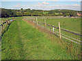
1
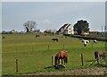
A view of Stubbinghill Farm
Clearly specialising in the accommodation of horses.
Image: © Neil Theasby
Taken: 20 Apr 2021
0.11 miles
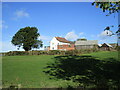
2
Stubbinghill Farm
View from dismantled railway next to Brierley Forest Park.
Image: © Alan Heardman
Taken: 3 Oct 2007
0.12 miles
3
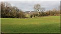
Silverhill Wood
This northerly facing photograph is looking across fields towards Silverhill Wood and was taken from Image
Image: © Alan Walker
Taken: 30 Jan 2018
0.12 miles
5
Public footpath west of Stanton Hill
Tracking northwards through the horse paddocks at Spring Wood Farm. In the distance on the right is Silverhill Wood - see Image
Image: © Trevor Rickard
Taken: 25 Sep 2010
0.15 miles
6
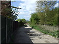
Track to Spring Wood Farm
Heading west from Stanton Hill.
Image: © JThomas
Taken: 18 Apr 2014
0.15 miles
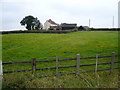
7
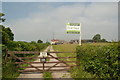
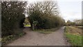
Gate and track off Brand Lane
Leading to Stubbinghill Farm, which is for sale.
Image: © Peter Barr
Taken: 8 Jul 2012
0.16 miles
8
The Brierley Branch Line
Ahead, the Brierley Branch Line continues toward the eastern edge of Brierley Forest Park. The Brierley Branch Line is part of the Phoenix Greenways Trails https://www.derbyshire.gov.uk/images/Phoenix%20Greenways%202015%20web_tcm44-159660.pdf and occupies what was the Midland Railway's Skegby Branch line.
The buildings are part of Stubbinghill Farm.
From close to this viewpoint on the trail there is this view of Image
To see a photograph of the trail taken some 130m ahead and looking back in this direction, click here:- Image
To see a photograph of the trail taken some 700m behind the viewpoint, click here:- Image
Image: © Alan Walker
Taken: 30 Jan 2018
0.16 miles
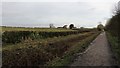
9
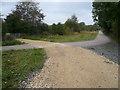
Dismantled Railway and Footpaths Cross
Image: © Alan Heardman
Taken: 3 Oct 2007
0.17 miles
10
The Brierley Branch Line
Ahead and to the right is the Brierley Branch Line. The Brierley Branch Line is part of the Phoenix Greenways Trails https://www.derbyshire.gov.uk/images/Phoenix%20Greenways%202015%20web_tcm44-159660.pdf and occupies what was the Midland Railway's Skegby Branch line.
The path leading off to the left leads ahead to Hardwick View or, shortly turning left again, links with Image
Behind the viewpoint the trail continues toward the eastern edge of Brierley Forest Park.
To see a photograph of the trail taken some 130m ahead and looking back in this direction, click here:- Image
To see a photograph of the trail taken some 80m behind the viewpoint and looking in the opposite direction, click here:- Image
Image: © Alan Walker
Taken: 30 Jan 2018
0.17 miles