IMAGES TAKEN NEAR TO
Cottonwood Road, SUTTON-IN-ASHFIELD, NG17 3LR
Introduction
This page details the photographs taken nearby to Cottonwood Road, NG17 3LR by members of the Geograph project.
The Geograph project started in 2005 with the aim of publishing, organising and preserving representative images for every square kilometre of Great Britain, Ireland and the Isle of Man.

There are currently over 7.5m images from over14,400 individuals and you can help contribute to the project by visiting https://www.geograph.org.uk
Image Map
Images are licensed for reuse under creativecommons.org/licenses/by-sa/2.0
Notes
- Clicking on the map will re-center to the selected point.
- The higher the marker number, the further away the image location is from the centre of the postcode.
Image Listing (26 Images Found)
Images are licensed for reuse under creativecommons.org/licenses/by-sa/2.0
Image
Details
Distance
1
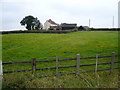
Stubbinghill Farm
View from dismantled railway next to Brierley Forest Park.
Image: © Alan Heardman
Taken: 3 Oct 2007
0.09 miles
2
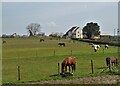
A view of Stubbinghill Farm
Clearly specialising in the accommodation of horses.
Image: © Neil Theasby
Taken: 20 Apr 2021
0.09 miles
4
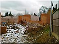
House under construction, Stanton Hill
Image: © Alex McGregor
Taken: 13 Feb 2012
0.12 miles
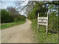
5
Gate and track off Brand Lane
Leading to Stubbinghill Farm, which is for sale.
Image: © Peter Barr
Taken: 8 Jul 2012
0.13 miles
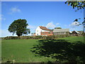
6
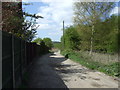
Track to Spring Wood Farm
Heading west from Stanton Hill.
Image: © JThomas
Taken: 18 Apr 2014
0.15 miles
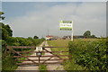
7
"Brierley Branch"
Once a railway branch line, now a leisure path linked with Brierley Forest Park near Huthwaite.
Image: © Neil Theasby
Taken: 20 Apr 2021
0.15 miles
8
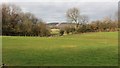
Silverhill Wood
This northerly facing photograph is looking across fields towards Silverhill Wood and was taken from Image
Image: © Alan Walker
Taken: 30 Jan 2018
0.16 miles
9
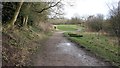
The Brierley Branch Line
The photograph shows the eastern end of the Brierley Branch Line. The Brierley Branch Line is part of the Phoenix Greenways Trails https://www.derbyshire.gov.uk/images/Phoenix%20Greenways%202015%20web_tcm44-159660.pdf and occupies what was the Midland Railway's Skegby Colliery Branch line.
Ahead can be seen a Image where the Brierley Branch Line meets other paths and lanes.
When this was a working railway there were sidings to the immediate right of this point and at the junction ahead there was a footbridge linking Brand Lane with Rooley Lane. Continuing ahead through what is now a slope the Midland Railway's Skegby Colliery Branch line passed through Sutton Colliery and terminated near a quarry close to Stoneyford Road.
An OS map dated 1892-14 from the National Library of Scotland https://maps.nls.uk/geo/explore/side-by-side/#zoom=17&lat=53.1365&lon=-1.2828&layers=168&right=osm shows the layout of the Skegby Colliery Branch tracks and the location of the footbridge.
To see a photograph of the trail taken some 80m behind the viewpoint and looking in the opposite direction, click here:- Image
Image: © Alan Walker
Taken: 30 Jan 2018
0.16 miles
10
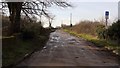
Brand Lane
This south-westerly facing photograph of Brand Lane in Stanton Hill was taken from the entrance to a small car park on the eastern edge of Brierley Forest Park and leads on to Stubbinghill Farm.
At this point, although marked as being a bridleway on OS maps, the lane is signposted as being private. Some 60m ahead and over the hedge to the left is a footpath leading into Image from the car park.
See this photograph, which was taken from the same viewpoint but facing in the opposite direction:- Image
See also this photograph by Peter Barr:- Image
Image: © Alan Walker
Taken: 30 Jan 2018
0.17 miles