IMAGES TAKEN NEAR TO
Coppywood Close, SUTTON-IN-ASHFIELD, NG17 3LL
Introduction
This page details the photographs taken nearby to Coppywood Close, NG17 3LL by members of the Geograph project.
The Geograph project started in 2005 with the aim of publishing, organising and preserving representative images for every square kilometre of Great Britain, Ireland and the Isle of Man.

There are currently over 7.5m images from over14,400 individuals and you can help contribute to the project by visiting https://www.geograph.org.uk
Image Map
Images are licensed for reuse under creativecommons.org/licenses/by-sa/2.0
Notes
- Clicking on the map will re-center to the selected point.
- The higher the marker number, the further away the image location is from the centre of the postcode.
Image Listing (33 Images Found)
Images are licensed for reuse under creativecommons.org/licenses/by-sa/2.0
Image
Details
Distance
1
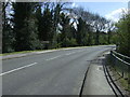
Entering Stanton Hill
Heading south east on the B6014.
Image: © JThomas
Taken: 18 Apr 2014
0.11 miles
2
Fackley, Sutton-in-Ashfield NG17, Notts.
Beyond the picnic area to the right of the Teversal Visitors' Centre a path connects the car parking area with "The Link Trail" where cyclists and walkers can leave or access either "The Skegby Trail" or "The Teversal Trail". Various other local amenities are situated on the right of this spot including Fackley Cricket Club's ground and a children's playground area. Carnarvon Street, behind the photographer, provides a link with Fackley Road (the B6014) that links Stanton Hill, Nottinghamshire and Tibshelf, Derbyshire.
Image: © David Hallam-Jones
Taken: 2 Mar 2013
0.12 miles
4
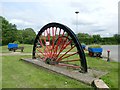
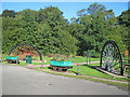
Teversal Coal Garden
Half winding wheels, coal tubs and a methane pump recovered from nearby Silverhill Colliery which closed in 1993
Image: © Graham Hogg
Taken: 12 Jun 2017
0.15 miles
5
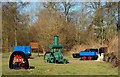
Fackley, Sutton-in-Ashfield NG17, Notts.
A few of the small number of permanent exhibits in "The Teversal Coal Garden" at the side of a footpath that links the Teversal Visitors' Centre and a ramblers' and cyclists' "Link Trail" 2-3 minutes walk ahead through the trees ahead. On view is an obsolete methane gas pump and two coal 'tubs' from the former Silverhill Colliery, plus a small winding wheel, all of which have been set into a grassed area as memorial to many former miners and of their pits.
Image: © David Hallam-Jones
Taken: 2 Mar 2013
0.15 miles
7
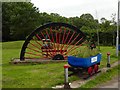
Teversal Coal Garden
Half winding wheels, coal tubs and a methane pump recovered from nearby Silverhill Colliery which closed in 1993 make up this garden at the Teversal Trails Visitors Centre
Image: © Graham Hogg
Taken: 12 Jun 2017
0.15 miles
8
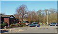
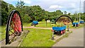
Teversal Coal Garden and visitor car park
The photograph shows the Teversal Coal Garden and visitor car park. On the right of the car park is the visitor's centre.
Behind the viewpoint is access to Image via Image and hence on to the Silverhill, Teversal and Skegby Trails.
See also these photographs by:-
Bobby Clegg, Image,
Graham Hogg, Image & Image,
Chris Morgan, Image and
David Hallam-Jones, Image
Image: © Alan Walker
Taken: 16 Jan 2018
0.15 miles
9
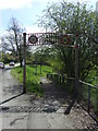
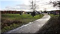
Entrance to the Teversal Trails Nature Reserve
This short path leads north to provide access to the Teversal Trail and a network of other paths, many using the old colliery railway routes. There is a large car park (shared with the pub) and a tea room. Created in 1988 by Ashfield District Council and Nottinghamshire County Council as the local pits were closing, the area is now a SSSI. The railways first came here in 1866 to service the growing coal mines and although closures started in the 1930s, the final route (Teversal to Pleasley) closed in 1978. Mining carried on at Silverhill until 1992 (see Image Image ), but since then nature (with a lot of landscaping help) has reclaimed the colliery sites and railway routes.
Image: © Trevor Rickard
Taken: 25 Sep 2010
0.16 miles
10
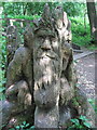
Green Man
This superb Green Man is carved into an old tree stump near to the Teversal Trails Visitors Centre. The Teversal Trails are concessionary footpaths that cover a range of old railway tracks and Colliery land.
Image: © Sally Holmes
Taken: 18 Jun 2006
0.16 miles