IMAGES TAKEN NEAR TO
Buttery Lane, SUTTON-IN-ASHFIELD, NG17 3LH
Introduction
This page details the photographs taken nearby to Buttery Lane, NG17 3LH by members of the Geograph project.
The Geograph project started in 2005 with the aim of publishing, organising and preserving representative images for every square kilometre of Great Britain, Ireland and the Isle of Man.

There are currently over 7.5m images from over14,400 individuals and you can help contribute to the project by visiting https://www.geograph.org.uk
Image Map
Images are licensed for reuse under creativecommons.org/licenses/by-sa/2.0
Notes
- Clicking on the map will re-center to the selected point.
- The higher the marker number, the further away the image location is from the centre of the postcode.
Image Listing (91 Images Found)
Images are licensed for reuse under creativecommons.org/licenses/by-sa/2.0
Image
Details
Distance
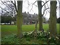
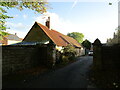
3
Teversal, Sutton-in-Ashfield NG17, Notts
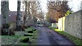
A small housing development on the south side of the St Katherine's Church on land that may have belonged to the owner of Manor Farm, situated behind the photographer. Unsecured gates at either end of this section of the lane seem to be aimed at discouraging its use as a 'through road' for the new inhabitants, seeking instead to persuade drivers to use Buttery Lane on the other side of the church.
Image: © David Hallam-Jones
Taken: 2 Mar 2013
0.01 miles
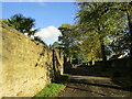
8
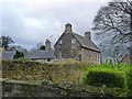
The Old Rectory, Teversal
Late 17th century house, refenestrated and extended in the 19th century. Listed Grade II, including the high garden wall in the centre of the picture.
Image: © Alan Murray-Rust
Taken: 30 Nov 2014
0.03 miles
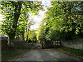
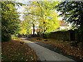
9
Buttery Lane, Teversal
The western end of Buttery Lane lies between Teversal Manor on the left and the parish church on the right. It would appear that at some point this route may have been the original Buttery Lane through the village and was later rerouted around the northern edge of the village. The newer route is also called Buttery Lane.
This section of Buttery Lane and the path through the gate ahead are a public footpath.
For another photograph of the lane some 100m behind the viewpoint, click here:- http://www.geograph.org.uk/photo/5647804
Image: © Alan Walker
Taken: 20 Jan 2017
0.03 miles
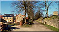
10
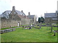
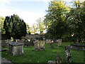
St. Katherine's Churchyard - Teversal
Image: © Alan Heardman
Taken: 13 Apr 2008
0.03 miles