IMAGES TAKEN NEAR TO
Teversal Village/Manor Close, Teversal Village, SUTTON-IN-ASHFIELD, NG17 3JN
Introduction
This page details the photographs taken nearby to Teversal Village/Manor Close, Teversal Village, NG17 3JN by members of the Geograph project.
The Geograph project started in 2005 with the aim of publishing, organising and preserving representative images for every square kilometre of Great Britain, Ireland and the Isle of Man.

There are currently over 7.5m images from over14,400 individuals and you can help contribute to the project by visiting https://www.geograph.org.uk
Image Map
Images are licensed for reuse under creativecommons.org/licenses/by-sa/2.0
Notes
- Clicking on the map will re-center to the selected point.
- The higher the marker number, the further away the image location is from the centre of the postcode.
Image Listing (123 Images Found)
Images are licensed for reuse under creativecommons.org/licenses/by-sa/2.0
Image
Details
Distance
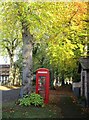
1
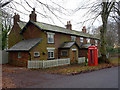
Cottages on Buttery Lane
Probably built as estate cottages for Teversal Manor.
Complete with postbox and K6 telephone kiosk.
Image: © Alan Murray-Rust
Taken: 30 Nov 2014
0.01 miles
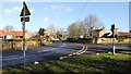
3
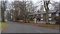
Teversal Village
Cottages at the western end of Buttery Lane from its junction with Pleasley Road.
For a photograph of the junction taken from the left of this viewpoint, click here:- Image
For another photograph of this section of Buttery Lane taken some 100m ahead and looking toward this viewpoint, click here:- Image
Image: © Alan Walker
Taken: 3 Nov 2015
0.02 miles
4
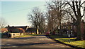
Teversal, Sutton-in-Ashfield NG17, Notts.
The view along Buttery Lane towards the Village Hall (a.k.a. The Manor Room) from Pleasley Road. There are no shops or pubs in the village and although the post box is operational the former telephone kiosk is now an enclosed community notice board.
Image: © David Hallam-Jones
Taken: 2 Mar 2013
0.02 miles
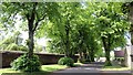
5
Autumn in Teversal
The phonebox is now a book exchange
Image: © Jonathan Thacker
Taken: 25 Oct 2021
0.02 miles
6
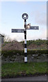
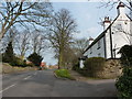
Fingerpost, Pleasley Road at Buttery Lane
This appears to be relatively modern, but is not the new standard Nottinghamshire design.
Image: © Alan Murray-Rust
Taken: 5 Dec 2014
0.03 miles
7
Buttery Lane, Teversal
The photograph shows the western end of Buttery Lane looking toward its junction with Pleasley Road.
For another photograph of this section of Buttery Lane taken some 100m ahead and looking back toward this viewpoint, click here:- Image
For a photograph taken from close by the same viewpoint but looking in the opposite direction, click here:- Image
Image: © Alan Walker
Taken: 25 May 2017
0.03 miles
8
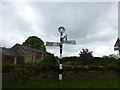
Old Direction Sign - Signpost by Pleasley Road, Teversal parish
Annulus finial - 3 arms; by the UC road, in parish of Teversal (Ashfield District), Teversal, Buttery Lane junction with Pleasley Road, on grass verge against stone wall.
Surveyed
Milestone Society National ID: NT_SK4861
Image: © Milestone Society
Taken: Unknown
0.03 miles
9
Pleasley Road, Teversal
The photograph shows Pleasley Road on the western edge of Teversal. On the right is Buttery Lane, which leads to Skegby.
See this photograph of Image, which shows Buttery Lane from this junction.
See also this photograph by David Hallam-Jones:- Image
Image: © Alan Walker
Taken: 15 Feb 2018
0.03 miles
10
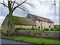
Dovecote Barn
Converted farm buildings at Teversal Farm.
Image: © Alan Murray-Rust
Taken: 30 Nov 2014
0.04 miles