IMAGES TAKEN NEAR TO
Skegby Hall Gardens, SUTTON-IN-ASHFIELD, NG17 3FX
Introduction
This page details the photographs taken nearby to Skegby Hall Gardens, NG17 3FX by members of the Geograph project.
The Geograph project started in 2005 with the aim of publishing, organising and preserving representative images for every square kilometre of Great Britain, Ireland and the Isle of Man.

There are currently over 7.5m images from over14,400 individuals and you can help contribute to the project by visiting https://www.geograph.org.uk
Image Map
Images are licensed for reuse under creativecommons.org/licenses/by-sa/2.0
Notes
- Clicking on the map will re-center to the selected point.
- The higher the marker number, the further away the image location is from the centre of the postcode.
Image Listing (45 Images Found)
Images are licensed for reuse under creativecommons.org/licenses/by-sa/2.0
Image
Details
Distance
1
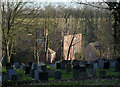
Skegby Hall
Not an easy building to photograph as it is surrounded by trees, so a winter afternoon is as good a time as any. This is the view from the churchyard. The hall is a square plan early Georgian house, built in 1720 as a replacement for the medieval Skegby Manor http://www.geograph.org.uk/photo/4274584. Listed Grade II.
Image: © Alan Murray-Rust
Taken: 5 Dec 2014
0.04 miles
2
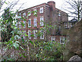
Skegby - Hall
Not a brilliant photo, but the best that could be achieved from the public road. Skegby Hall and gardens were built around 1720, on the grounds of a much earlier dwelling, by the Lindley family. At one stage it was in public ownership as an approved school.
Image: © Dave Bevis
Taken: 21 Nov 2010
0.05 miles
3
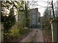
Skegby Hall
Not an easy building to photograph as it is surrounded by trees, so a winter afternoon is as good a time as any. This is a square plan early Georgian house, built in 1720 as a replacement for the medieval Skegby Manor http://www.geograph.org.uk/photo/4274584. Listed Grade II.
Image: © Alan Murray-Rust
Taken: 5 Dec 2014
0.05 miles
4
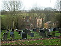
Churchyard and view to Skegby Hall in the trees
Looking down the slope below the church.
Image: © Andrew Hill
Taken: 1 Dec 2011
0.06 miles
5
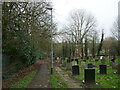
Footpath to Mansfield Road, Skegby
Runs along the edge of the churchyard.
Image: © Jonathan Thacker
Taken: 29 Feb 2024
0.06 miles
6
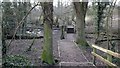
Footbridge over a stream
Leading off from a Image that runs between the Skegby Trail and Mansfield Road in Skegby this path leads into a small area of woodland and a footbridge over a stream. The stream (unnamed on the OS map) is a Image
Image: © Alan Walker
Taken: 7 Mar 2018
0.07 miles
7
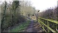
Public footpath
The photograph shows the northern end of a public footpath that runs from the Skegby Trail to Mansfield Road, Skegby.
To see a photograph of the path taken a few metres behind the viewpoint, click here Image
Just behind the viewpoint and to the left another path leads to a Image
Image: © Alan Walker
Taken: 7 Mar 2018
0.07 miles
9
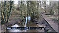
Tributary of the River Meden
This photograph was take from a Image The stream (unnamed on the OS map) is a tributary of the River Meden.
See also this photograph by Andy Stephenson, which was taken in the same woodland but a little further upstream, Image
Image: © Alan Walker
Taken: 7 Mar 2018
0.08 miles
10
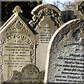
Sunlit gravestones
Typical Victorian gravestones with florid decoration.
Image: © Alan Murray-Rust
Taken: 5 Dec 2014
0.08 miles