IMAGES TAKEN NEAR TO
Brierley Park Close, SUTTON-IN-ASHFIELD, NG17 3FW
Introduction
This page details the photographs taken nearby to Brierley Park Close, NG17 3FW by members of the Geograph project.
The Geograph project started in 2005 with the aim of publishing, organising and preserving representative images for every square kilometre of Great Britain, Ireland and the Isle of Man.

There are currently over 7.5m images from over14,400 individuals and you can help contribute to the project by visiting https://www.geograph.org.uk
Image Map
Images are licensed for reuse under creativecommons.org/licenses/by-sa/2.0
Notes
- Clicking on the map will re-center to the selected point.
- The higher the marker number, the further away the image location is from the centre of the postcode.
Image Listing (32 Images Found)
Images are licensed for reuse under creativecommons.org/licenses/by-sa/2.0
Image
Details
Distance
1
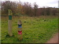
Trail Guide Posts
Mini totem poles on the Teversal Trail network at Stanton Hill
Image: © John Poyser
Taken: 30 Nov 2006
0.05 miles
2
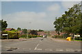
Brand Lane
This north-easterly facing photograph of Brand Lane in Stanton Hill was taken from the entrance to a small car park on the eastern edge of Brierley Forest Park.
See this photograph, which was taken from the same viewpoint but facing in the opposite direction:- Image
See also this photograph by Dave Bevis, which was taken at the other end of the lane:- Image
Image: © Alan Walker
Taken: 30 Jan 2018
0.07 miles
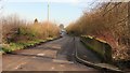
5
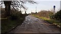
Brand Lane
This south-westerly facing photograph of Brand Lane in Stanton Hill was taken from the entrance to a small car park on the eastern edge of Brierley Forest Park and leads on to Stubbinghill Farm.
At this point, although marked as being a bridleway on OS maps, the lane is signposted as being private. Some 60m ahead and over the hedge to the left is a footpath leading into Image from the car park.
See this photograph, which was taken from the same viewpoint but facing in the opposite direction:- Image
See also this photograph by Peter Barr:- Image
Image: © Alan Walker
Taken: 30 Jan 2018
0.12 miles
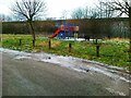
6
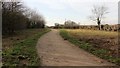
Brierley Forest Park
This footpath leads from a small car park some 60m behind the viewpoint into the eastern quarter of Brierley Forest Park.
At this point the footpath runs parallel to Image, which is just over the hedge to the left of the photograph.
Image: © Alan Walker
Taken: 30 Jan 2018
0.14 miles
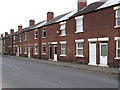
8
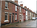
Stanton Hill - terraced housing on Institute Street
Image: © Dave Bevis
Taken: 7 Apr 2016
0.16 miles
9
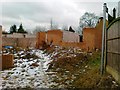
House under construction, Stanton Hill
Image: © Alex McGregor
Taken: 13 Feb 2012
0.17 miles
10
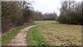
Path near the eastern edge of Brierley Forest Park
Ahead this path follows the approximate route of the Midland Railway's Skegby Colliery Branch. Not far beyond the bend in the distance is an Image
A short distance behind the viewpoint are paths leading to Stanton Hill, the Brierley Forest Visitor Centre, Carsic Bank, a Image and Rooley Tops.
To the left of the path is Brierley Park Industrial Estate, part of which is built on the site of the former Sutton Colliery as can be seen from this OS map dated 1892-14 from the National Library of Scotland https://maps.nls.uk/geo/explore/side-by-side/#zoom=17&lat=53.1371&lon=-1.2764&layers=168&right=osm .
Image: © Alan Walker
Taken: 11 Mar 2018
0.17 miles