IMAGES TAKEN NEAR TO
Barker Avenue, SUTTON-IN-ASHFIELD, NG17 3FP
Introduction
This page details the photographs taken nearby to Barker Avenue, NG17 3FP by members of the Geograph project.
The Geograph project started in 2005 with the aim of publishing, organising and preserving representative images for every square kilometre of Great Britain, Ireland and the Isle of Man.

There are currently over 7.5m images from over14,400 individuals and you can help contribute to the project by visiting https://www.geograph.org.uk
Image Map
Images are licensed for reuse under creativecommons.org/licenses/by-sa/2.0
Notes
- Clicking on the map will re-center to the selected point.
- The higher the marker number, the further away the image location is from the centre of the postcode.
Image Listing (8 Images Found)
Images are licensed for reuse under creativecommons.org/licenses/by-sa/2.0
Image
Details
Distance
2
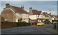
Hazel Street, Skegby
A residential street north of the B6014.
Image: © Andrew Hill
Taken: 1 Dec 2011
0.15 miles
4
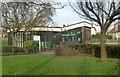
Skegby and Stanton Hill library
An attractive modern library building by the B6014 Fackley Road.
Image: © Andrew Hill
Taken: 1 Dec 2011
0.17 miles
5
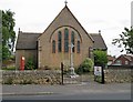
Stanton Hill - All Saints Church
On Fackley Road.
Image: © Dave Bevis
Taken: 18 Jun 2015
0.18 miles
6
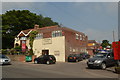
Woodside Surgery
On the road between Skegby and Stanton Hill. Also a 4 * 4 garage and a British Legion Club.
Image: © Peter Barr
Taken: 8 Jul 2012
0.23 miles
7
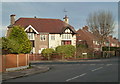
Corner of Elder Street and Hazel Street, Skegby
A well established housing estate north of the B6014.
Image: © Andrew Hill
Taken: 1 Dec 2011
0.23 miles
8
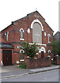
Stanton Hill - General Baptist Chapel
On Albert Street.
Image: © Dave Bevis
Taken: 12 Oct 2010
0.25 miles