IMAGES TAKEN NEAR TO
Mansfield Road, SUTTON-IN-ASHFIELD, NG17 3DW
Introduction
This page details the photographs taken nearby to Mansfield Road, NG17 3DW by members of the Geograph project.
The Geograph project started in 2005 with the aim of publishing, organising and preserving representative images for every square kilometre of Great Britain, Ireland and the Isle of Man.

There are currently over 7.5m images from over14,400 individuals and you can help contribute to the project by visiting https://www.geograph.org.uk
Image Map
Images are licensed for reuse under creativecommons.org/licenses/by-sa/2.0
Notes
- Clicking on the map will re-center to the selected point.
- The higher the marker number, the further away the image location is from the centre of the postcode.
Image Listing (50 Images Found)
Images are licensed for reuse under creativecommons.org/licenses/by-sa/2.0
Image
Details
Distance
1
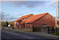
Skegby Methodist Church
The new church and social centre replaced the earlier 19th century chapel in 2005.
Image: © Alan Murray-Rust
Taken: 5 Dec 2014
0.02 miles
2
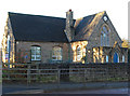
Skegby - St Andrews School
According to a metal plaque on the school perimeter wall, built in 1866 on land donated by Lady Carnarvon.
Image: © Dave Bevis
Taken: 1 Dec 2013
0.03 miles
3
St Andrews C of E School
Built in 1865 on land donated by Lady Carnarvon. There are substantial extensions out of picture to the left.
Image: © Alan Murray-Rust
Taken: 5 Dec 2014
0.03 miles
5
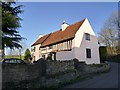
Kruck Cottage, Skegby
The oldest still-inhabited building in Skegby. The timber framed section dates back to the 16th century, the farther bay being a late 19th century addition. Despite the name, the listing description makes no reference to surviving cruck frames. Listed Grade II.
Image: © Alan Murray-Rust
Taken: 5 Dec 2014
0.08 miles
6
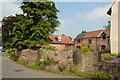
Cottages, and Kruck Cottage
Kruck (sic) Cottage takes its name from the cruck frame construction, and is said to be the oldest occupied dwelling remaining in Skegby.
Image: © Peter Barr
Taken: 8 Jul 2012
0.08 miles
7
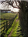
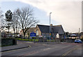
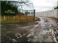
Sunlit footpath
Leading from Back Lane to Mansfield Road.
Image: © Alan Murray-Rust
Taken: 5 Dec 2014
0.08 miles
8
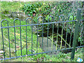
Skegby Troughs
Thought to be at least 200 years old, these were created for the watering of animals, and are fed directly from a spring. Restored by local volunteers in 2007. They are alongside the old road through the village, the high level section of Mansfield Road above the troughs having been built sometime around 1850.
Image: © Alan Murray-Rust
Taken: 5 Dec 2014
0.09 miles
10
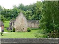
Skegby Manor House
A grade II listed manor house dating from the 13th century, now a roofless ruin. The house is also a scheduled ancient monument.
Image: © Graham Hogg
Taken: 12 Jun 2017
0.12 miles