IMAGES TAKEN NEAR TO
Vicarage Court, SUTTON-IN-ASHFIELD, NG17 3DD
Introduction
This page details the photographs taken nearby to Vicarage Court, NG17 3DD by members of the Geograph project.
The Geograph project started in 2005 with the aim of publishing, organising and preserving representative images for every square kilometre of Great Britain, Ireland and the Isle of Man.

There are currently over 7.5m images from over14,400 individuals and you can help contribute to the project by visiting https://www.geograph.org.uk
Image Map
Images are licensed for reuse under creativecommons.org/licenses/by-sa/2.0
Notes
- Clicking on the map will re-center to the selected point.
- The higher the marker number, the further away the image location is from the centre of the postcode.
Image Listing (49 Images Found)
Images are licensed for reuse under creativecommons.org/licenses/by-sa/2.0
Image
Details
Distance
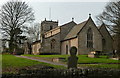
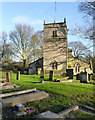
2
Skegby - Church
For an alternative view of St Andrew's Church, please see Image
Image: © Dave Bevis
Taken: 7 Nov 2010
0.06 miles
3
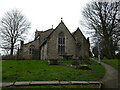
St Andrew's church, Skegby, from the east
This medieval church has been much rebuilt and extended, the chancel as recently as 1984 https://historicengland.org.uk/listing/the-list/list-entry/1234873?section=official-list-entry
Image: © Jonathan Thacker
Taken: 29 Feb 2024
0.06 miles
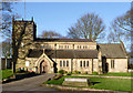
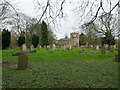
4
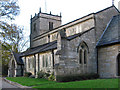
Church of St Andrew, Skegby
A grade II listed parish church dating from the 13th century.
Image: © Graham Hogg
Taken: 12 Jun 2017
0.07 miles
5
Church of St Andrew, Skegby
The church is attractively set back on a hill, not in sight from the road.
Image: © Andrew Hill
Taken: 1 Dec 2011
0.07 miles
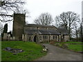
6
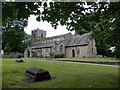
Church of St Andrew, Skegby
View from the south.
The church was originally a chapel of ease of Mansfield St Peter, a separate parish not being formed until 1860 when the village expanded due to coal mining. The tower is mainly 13th century, but the church was largely rebuilt in the late 19th century due to mining subsidence, and this also resulted in the chancel having to be rebuilt completely in 1984. Listed Grade II.
Image: © Alan Murray-Rust
Taken: 5 Dec 2014
0.07 miles
7
St Andrew's church, Skegby
A much altered medieval church https://historicengland.org.uk/listing/the-list/list-entry/1431431?section=official-list-entry
Image: © Jonathan Thacker
Taken: 29 Feb 2024
0.07 miles
8
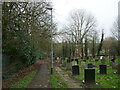
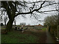
Footpath to Mansfield Road, Skegby
Runs along the edge of the churchyard.
Image: © Jonathan Thacker
Taken: 29 Feb 2024
0.07 miles
9
Church of St Andrew, Skegby
The west tower represents the oldest surviving external masonry, dating to the 13th century. Listed Grade II.
Image: © Alan Murray-Rust
Taken: 5 Dec 2014
0.07 miles
10
St Andrew's church, Skegby
The church stands more or less in the middle of a large churchyard.
Image: © Jonathan Thacker
Taken: 29 Feb 2024
0.07 miles