IMAGES TAKEN NEAR TO
Blackwell Road, SUTTON-IN-ASHFIELD, NG17 2RF
Introduction
This page details the photographs taken nearby to Blackwell Road, NG17 2RF by members of the Geograph project.
The Geograph project started in 2005 with the aim of publishing, organising and preserving representative images for every square kilometre of Great Britain, Ireland and the Isle of Man.

There are currently over 7.5m images from over14,400 individuals and you can help contribute to the project by visiting https://www.geograph.org.uk
Image Map
Images are licensed for reuse under creativecommons.org/licenses/by-sa/2.0
Notes
- Clicking on the map will re-center to the selected point.
- The higher the marker number, the further away the image location is from the centre of the postcode.
Image Listing (3 Images Found)
Images are licensed for reuse under creativecommons.org/licenses/by-sa/2.0
Image
Details
Distance
2
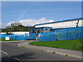
A distribution centre on The Countryside Estate
A rather strange name for an industrial estate! The Countryside Estate is one of many industrial estates in the area because of the close proximity of the M1.
Image: © Nikki Mahadevan
Taken: 19 Sep 2006
0.19 miles
3
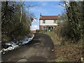
Grazing Land near Blackwell Road, Huthwaite
The building on the right is the rear of what was the Miners Arms (which closed in 2008) - originally believed to be a pit manager's cottage. The house on the left is the 'Dog About Town' Pet Hotel. The Derbyshire / Nottinghamshire county boundary also runs between these 2 buildings.
Image: © Jonathan Clitheroe
Taken: 15 Mar 2013
0.22 miles