IMAGES TAKEN NEAR TO
Strawberry Bank, SUTTON-IN-ASHFIELD, NG17 2QG
Introduction
This page details the photographs taken nearby to Strawberry Bank, NG17 2QG by members of the Geograph project.
The Geograph project started in 2005 with the aim of publishing, organising and preserving representative images for every square kilometre of Great Britain, Ireland and the Isle of Man.

There are currently over 7.5m images from over14,400 individuals and you can help contribute to the project by visiting https://www.geograph.org.uk
Image Map
Images are licensed for reuse under creativecommons.org/licenses/by-sa/2.0
Notes
- Clicking on the map will re-center to the selected point.
- The higher the marker number, the further away the image location is from the centre of the postcode.
Image Listing (28 Images Found)
Images are licensed for reuse under creativecommons.org/licenses/by-sa/2.0
Image
Details
Distance
1
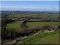
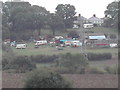
Huthwaite - Strawberry Bank
View west towards South Normanton, Old Blackwell and Alfreton. Strawberry Bank is one of several places that claims to be the highest point in Nottinghamshire.
Image: © Dave Bevis
Taken: 13 Mar 2005
0.02 miles

6
Woodland Cottage and Strawberry Bank
looking SE across the fields the houses are in Strawberry Bank
Image: © Tom Courtney
Taken: 29 Sep 2005
0.08 miles
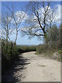
7
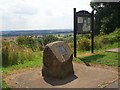
Toposcope on Strawberry Bank
There is an extensive view from here over the Erewash Valley.
Image: © Graham Hogg
Taken: 26 Jul 2021
0.10 miles
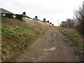
8

Viewpoint on Strawberry Bank in Huthwaite
Image: © Jonathan Clitheroe
Taken: 5 Oct 2022
0.10 miles
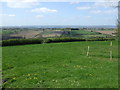
9
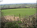
Huthwaite - View across farmland from Strawberry Bank
Image: © Alan Heardman
Taken: 11 Mar 2009
0.10 miles
10

Strawberry Bank
The plaque claims this to be the highest natural point in Nottinghamshire, at 201 metres or 660 feet above sea level.
Image: © Peter Barr
Taken: 8 Jul 2012
0.10 miles