IMAGES TAKEN NEAR TO
Lime Avenue, SUTTON-IN-ASHFIELD, NG17 2NR
Introduction
This page details the photographs taken nearby to Lime Avenue, NG17 2NR by members of the Geograph project.
The Geograph project started in 2005 with the aim of publishing, organising and preserving representative images for every square kilometre of Great Britain, Ireland and the Isle of Man.

There are currently over 7.5m images from over14,400 individuals and you can help contribute to the project by visiting https://www.geograph.org.uk
Image Map
Images are licensed for reuse under creativecommons.org/licenses/by-sa/2.0
Notes
- Clicking on the map will re-center to the selected point.
- The higher the marker number, the further away the image location is from the centre of the postcode.
Image Listing (31 Images Found)
Images are licensed for reuse under creativecommons.org/licenses/by-sa/2.0
Image
Details
Distance
2
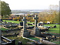
Huthwaite - cemetery
View towards The Common.
Image: © Dave Bevis
Taken: 30 Oct 2010
0.06 miles
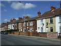
5
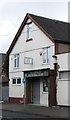
Huthwaite - Victoria Club
On North Street.
Image: © Dave Bevis
Taken: 2 Apr 2013
0.10 miles
6
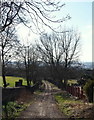
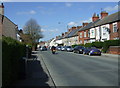
Huthwaite, Sutton-in-Ashfield, NG17, Notts.
Mill Lane, a reverse L-shaped unsurfaced track, links Sutton Road (the B6026) and Common Road (B6027). On the left is a secondary entrance to Huthwaite Cemetery. The gates are open during its opening hours but only to pedestrians as vehicules are no longer permitted to use the track. Huthwaite Cemetery was formally opened in 1888 to cater for the burial of local people once the graveyard of the Church of St Mary Magdalene in Sutton was full. In 1912, and again in 1915, Huthwaite Urban District Council purchased additional land (seen here) on the site of a former farm, Mill House Farm. The farm house faced this lane and parts of this stone wall once served as one of the farm's boundary walls. Use of the word "mill" stems from the existence of a windmill on top of the hill that forms the main part of the cemetery.
Image: © David Hallam-Jones
Taken: 2 Mar 2013
0.11 miles
7
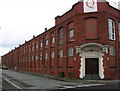
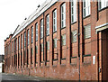
Huthwaite - former CWS hosiery factory - S block
For more information on this factory, please see Image
Image: © Dave Bevis
Taken: 16 Jun 2007
0.11 miles
8
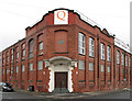
Huthwaite - former CWS hosiery factory - 1907 entrance
This large factory occupies most of a rectangular site extending about 475 ft north-south along North Street and 350ft east-west along High Street in Huthwaite. When first built in 1907, it only extended 230ft along North Street, but was expanded in 1919 further down North Street. Various buildings had been added later, the most recent being the block along the north side of the site. In 1940, the British Royal Navy took over this 4-storey block to be the headquarters of their medical supply department for most of World War II. The architect of the 1907 building was Mr. F.E. Harris of Manchester and the contractor Mr. J. Dickinson of Derby.
The factory was built by the Cooperative Wholesale Society (CWS) for the
manufacture of hosiery. It is sometimes referred to as the Belmont Clothing Factory, but I suspect that "Belmont" was a clothing brand name, rather than the name of the building.
When first opened, it was expected to employ 400 people, but probably employed even more in its heyday. It was certainly the major employer of female labour in Huthwaite (New Hucknall Colliery being the major employee of males).
At some point, the hosiery factory became part of the Coats Viyella company. Coats Viyella was once one of the UK’s leading textile businesses with retail (Jaeger), thread (Coats) and manufacturing (CV Clothing) businesses. The building is currently occupied by the Quantum Clothing Group. Quantum was created as a management buy-out from Coats Viyella in December 2000 and currently employs around 5000 people worldwide. All the business’s UK operations including warehousing, design, development, commercial and finance operate from this site in Huthwaite, together with a small office in Ireland. In July 2012, the Quantum Clothing Group was acquired by Japanese conglomerate Itochu Corp. In April 2015, Ashfield District Council granted planning permission for the "demolition of the existing warehousing and factory complex".
For more web-based information on this factory, please see http://www.huthwaite-online.net/hucknall/press/1907-cws.php , http://en.wikipedia.org/wiki/Huthwaite#Hosiery_Factory , http://archiveshub.ac.uk/search/summary.html?rsid=1310488424&startRecord=1&maximumRecords=20&hitposition=1#rightcol , http://www.quantumclothing.com/AboutUs.aspx and
http://www.knittingindustry.com/quantum-clothing-acquired-by-itochu/ .
For further images of this factory please see Image, Image, Image, Image and Image
Image: © Dave Bevis
Taken: 2 Apr 2013
0.12 miles
9
Huthwaite - former CWS hosiery factory - S end of E block
For more information on this factory, please see Image
Image: © Dave Bevis
Taken: 2 Apr 2013
0.13 miles
10
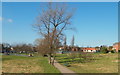
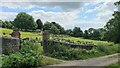
Huthwaite, Sutton-in-Ashfield NG17, Notts
"The Huthwaite (miners') Welfare (recreation) Ground" is sandwiched between Columbia Street and Mill Lane, an unsurfaced track from where this picture was taken. Both of these plummet downhill from the main road that passes through Huthwaite i.e. the B6026. This land was donated for community use by the New Hucknall Colliery Company and the original access to it when it first opened in 1920 was via a set of gates off Columbia Street. The newer 'main entrance', off the B6026, was created later. A path, beneath this one, connected these two thoroughfares and was regularly walked by coal miners going to and from the New Hucknall Colliery.
a miners welfare sports ground, pavilion and recreation ground in Columbia Street, Sutton Road.
Image: © David Hallam-Jones
Taken: 2 Mar 2013
0.13 miles