IMAGES TAKEN NEAR TO
Roberts Avenue, SUTTON-IN-ASHFIELD, NG17 2JP
Introduction
This page details the photographs taken nearby to Roberts Avenue, NG17 2JP by members of the Geograph project.
The Geograph project started in 2005 with the aim of publishing, organising and preserving representative images for every square kilometre of Great Britain, Ireland and the Isle of Man.

There are currently over 7.5m images from over14,400 individuals and you can help contribute to the project by visiting https://www.geograph.org.uk
Image Map
Images are licensed for reuse under creativecommons.org/licenses/by-sa/2.0
Notes
- Clicking on the map will re-center to the selected point.
- The higher the marker number, the further away the image location is from the centre of the postcode.
Image Listing (17 Images Found)
Images are licensed for reuse under creativecommons.org/licenses/by-sa/2.0
Image
Details
Distance
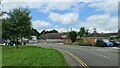
1
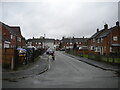
South end of Greenwood Avenue, Huthwaite
Off Cross Lane.
Image: © Richard Vince
Taken: 12 Dec 2020
0.09 miles
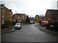
4
Carnarvon Road, Huthwaite
Off Common Road.
Image: © Richard Vince
Taken: 12 Dec 2020
0.13 miles
6
East end of Greenwood Avenue, Huthwaite
Off Columbia Street.
Image: © Richard Vince
Taken: 12 Dec 2020
0.15 miles
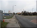
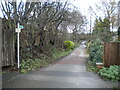
7
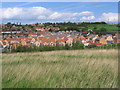
Housing north of Mill Lane
The photograph was taken from the footpath to the south of Mill Lane. The western boundary of an old colliery, which is currently being landfilled, can be seen to the right of the picture Image
Image: © Nikki Mahadevan
Taken: 19 Sep 2006
0.16 miles
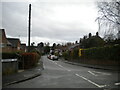
8
Huthwaite : Brookside Way
Looking off Common Road.
Image: © Lewis Clarke
Taken: 2 Oct 2018
0.16 miles
9
Mercia Court, Huthwaite
A residential cul de sac off Cross Lane.
Image: © Richard Vince
Taken: 12 Dec 2020
0.17 miles
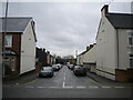
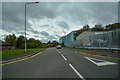
10
East end of Cross Lane, Huthwaite
At this point, it becomes a restricted byway.
Image: © Richard Vince
Taken: 12 Dec 2020
0.18 miles