IMAGES TAKEN NEAR TO
Oakland Avenue, SUTTON-IN-ASHFIELD, NG17 2JE
Introduction
This page details the photographs taken nearby to Oakland Avenue, NG17 2JE by members of the Geograph project.
The Geograph project started in 2005 with the aim of publishing, organising and preserving representative images for every square kilometre of Great Britain, Ireland and the Isle of Man.

There are currently over 7.5m images from over14,400 individuals and you can help contribute to the project by visiting https://www.geograph.org.uk
Image Map
Images are licensed for reuse under creativecommons.org/licenses/by-sa/2.0
Notes
- Clicking on the map will re-center to the selected point.
- The higher the marker number, the further away the image location is from the centre of the postcode.
Image Listing (43 Images Found)
Images are licensed for reuse under creativecommons.org/licenses/by-sa/2.0
Image
Details
Distance
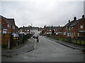
1
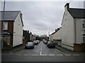
South end of Farnsworth Grove, Huthwaite
Off Columbia Street.
Image: © Richard Vince
Taken: 12 Dec 2020
0.07 miles
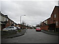
2
East end of Greenwood Avenue, Huthwaite
Off Columbia Street.
Image: © Richard Vince
Taken: 12 Dec 2020
0.12 miles
3
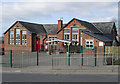
Huthwaite - All Saints Infant School
On Common Road.
Image: © Dave Bevis
Taken: 6 Apr 2013
0.12 miles
4
South end of Greenwood Avenue, Huthwaite
Off Cross Lane.
Image: © Richard Vince
Taken: 12 Dec 2020
0.12 miles
5

Welfare Park, Huthwaite (1)
Seen from the Columbia Street entrance.
Image: © Richard Vince
Taken: 12 Dec 2020
0.14 miles
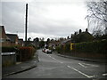
6
Carnarvon Road, Huthwaite
Off Common Road.
Image: © Richard Vince
Taken: 12 Dec 2020
0.15 miles
7
Huthwaite - All Saints Church
Built in 1902/03, this was the first proper Anglican church in Huthwaite. Previously, Huthwaite people had to travel to the parish church in Sutton-in-Ashfield or, from 1868, they could attend a mission church set up in the south wing of the newly-built Blackwell Road Schools. When the foundation stone was laid in 1902, it was said that "the church will be of fine proportions, and dignified in its architectural character and, when complete, and will be dedicated to All Saints". The New Hucknall Colliery Company gave the rock of which the Church is built. The Church was "believed to be the only one in the country built from rock taken from a depth of 400 yards below the surface. The pillars and facings are of Mansfield stone". The architect was Mr. C. Ford Whitcombe, of London, and the building was undertaken by Mr. A. B. Clarke of Nottingham. Please see http://www.huthwaite-online.net/hucknall/press/1902-foundations.php and
http://www.huthwaite-online.net/hucknall/press/1933-parish.php for more historical details.
Image: © Dave Bevis
Taken: 6 Apr 2013
0.15 miles
8
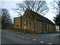
All Saints' church, Huthwaite
Built 1903-4 and designed by C A Ford Whitcombe https://en.wikipedia.org/wiki/Charles_Arthur_Ford_Whitcombe
Image: © Jonathan Thacker
Taken: 16 Feb 2024
0.15 miles
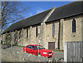
10
Huthwaite, Sutton-in-Ashfield NG17, Notts
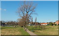
"The Huthwaite (miners') Welfare (recreation) Ground" is sandwiched between Columbia Street and Mill Lane, an unsurfaced track from where this picture was taken. Both of these plummet downhill from the main road that passes through Huthwaite i.e. the B6026. This land was donated for community use by the New Hucknall Colliery Company and the original access to it when it first opened in 1920 was via a set of gates off Columbia Street. The newer 'main entrance', off the B6026, was created later. A path, beneath this one, connected these two thoroughfares and was regularly walked by coal miners going to and from the New Hucknall Colliery.
a miners welfare sports ground, pavilion and recreation ground in Columbia Street, Sutton Road.
Image: © David Hallam-Jones
Taken: 2 Mar 2013
0.17 miles