IMAGES TAKEN NEAR TO
Rooley Drive, SUTTON-IN-ASHFIELD, NG17 2EY
Introduction
This page details the photographs taken nearby to Rooley Drive, NG17 2EY by members of the Geograph project.
The Geograph project started in 2005 with the aim of publishing, organising and preserving representative images for every square kilometre of Great Britain, Ireland and the Isle of Man.

There are currently over 7.5m images from over14,400 individuals and you can help contribute to the project by visiting https://www.geograph.org.uk
Image Map (Loading...)


Getting Data...Please wait
Leaflet Map data © OpenStreetMap
Images are licensed for reuse under creativecommons.org/licenses/by-sa/2.0
Notes
- Clicking on the map will re-center to the selected point.
- The higher the marker number, the further away the image location is from the centre of the postcode.
Image Listing (3 Images Found)
Images are licensed for reuse under creativecommons.org/licenses/by-sa/2.0
Image
Details
Distance
1
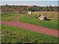
Sutton Colliery Memorial
Simple memorial at a path junction at Brierley Forest Park. A large factory at Sutton in the background.
On 21st February 1957 an explosion occurred in the Low Main Seam at the colliery and 25 men suffered multiple burns. Five men subsequently died as a result of their injuries.
The inscription on the memorial reads 'In commemoration of the five miners who died in 1957 Sutton Colliery (Brierley Pit) disaster and in tribute to all those who worked at the colliery 1872-1989, laid on behalf of the local community by the friends of Brierley Forest Park 2003'.
Image: © Trevor Rickard
Taken: 25 Sep 2010
0.22 miles
2
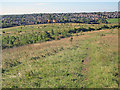
Brierley Forest Park
Looking south towards Sutton In Ashfield. This site was originally the waste tip from Sutton Colliery, known locally as 'Brierley Colliery' (possibly renamed by the Staffordshire colliers who moved here from the Brierley Hill area), or the 'Bread and Herring Pit' because of the poor condition of the colliery. The colliery closed in 1989 and, following landscaping, the site is now a country park.
http://www.ashfield-dc.gov.uk/ccm/content/leisure-and-culture/parks-and-recreation/parks-and-recreation.en?page=2
Image: © Trevor Rickard
Taken: 25 Sep 2010
0.24 miles
3
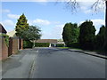
Springwood View Close
North of Huthwaite Road.
Image: © JThomas
Taken: 18 Apr 2014
0.25 miles