IMAGES TAKEN NEAR TO
Brook Street, SUTTON-IN-ASHFIELD, NG17 1NZ
Introduction
This page details the photographs taken nearby to Brook Street, NG17 1NZ by members of the Geograph project.
The Geograph project started in 2005 with the aim of publishing, organising and preserving representative images for every square kilometre of Great Britain, Ireland and the Isle of Man.

There are currently over 7.5m images from over14,400 individuals and you can help contribute to the project by visiting https://www.geograph.org.uk
Image Map
Images are licensed for reuse under creativecommons.org/licenses/by-sa/2.0
Notes
- Clicking on the map will re-center to the selected point.
- The higher the marker number, the further away the image location is from the centre of the postcode.
Image Listing (87 Images Found)
Images are licensed for reuse under creativecommons.org/licenses/by-sa/2.0
Image
Details
Distance
1

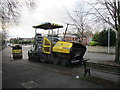
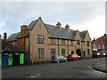
Sutton-in-Ashfield - Brook Street Court
This office building under construction, on Brook Street, has retained part of the frontage of the former swimming baths. These were closed in 2008 - see Image for more details.
Image: © Dave Bevis
Taken: 1 Mar 2015
0.01 miles
2
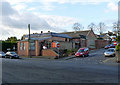
Sutton-in-Ashfield - Public Baths
On Brook Street. Opened in 1924. Closed on 30 October 2008. A replacement baths is provided at the Lammas Leisure Centre 400 metres away and is pictured at Image For more information on the Brook Street Baths, please see http://www.ournottinghamshire.org.uk/page_id__516.aspx .
Image: © Dave Bevis
Taken: 25 Oct 2008
0.02 miles
3
St John's Methodist Church, Sutton-in-Ashfield
Relative to their extent, the buildings make a low-key architectural statement.
Image: © Alan Murray-Rust
Taken: 5 Dec 2014
0.04 miles
4
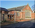
Sutton-in-Ashfield - St John's Methodist Church
On Titchfield Avenue. For an alternative view, please see Image
Image: © Dave Bevis
Taken: 1 Mar 2015
0.04 miles
6
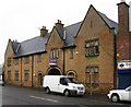
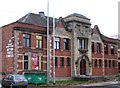
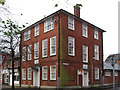
Sutton-in-Ashfield - former UDC offices
On Brook Street. The building was constructed during the Edwardian period as a police station, according to Ashfield District Council's "Criteria for Local Heritage Asset Designation" published in February 2013. The current police station is on Church Street and was constructed in the 1960's.
Image: © Dave Bevis
Taken: 26 Nov 2012
0.08 miles
7
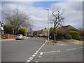
Junction of Church Street and Church Hill, Sutton in Ashfield
Church Street heads straight ahead into the town centre; Church Hill heads off downhill to the right.
Image: © Richard Vince
Taken: 6 Apr 2019
0.09 miles
9
The Old Police Station, Sutton in Ashfield
Image: © Jonathan Thacker
Taken: 12 Jan 2020
0.09 miles
10
Sutton-in-Ashfield - former post office
On Brook Street. Sutton's post office relocated to a newer building across the street in the 1970's (see http://www.picturethepast.org.uk/frontend.php?keywords=Ref_No_increment;EQUALS;NCCW002281&pos=6&action=zoom&id=51257 ). Later, it moved again to inside the ASDA store on Priestsic Road.
Image: © Dave Bevis
Taken: 26 Nov 2012
0.10 miles