IMAGES TAKEN NEAR TO
Netherfield Grange, SUTTON-IN-ASHFIELD, NG17 1LE
Introduction
This page details the photographs taken nearby to Netherfield Grange, NG17 1LE by members of the Geograph project.
The Geograph project started in 2005 with the aim of publishing, organising and preserving representative images for every square kilometre of Great Britain, Ireland and the Isle of Man.

There are currently over 7.5m images from over14,400 individuals and you can help contribute to the project by visiting https://www.geograph.org.uk
Image Map
Images are licensed for reuse under creativecommons.org/licenses/by-sa/2.0
Notes
- Clicking on the map will re-center to the selected point.
- The higher the marker number, the further away the image location is from the centre of the postcode.
Image Listing (7 Images Found)
Images are licensed for reuse under creativecommons.org/licenses/by-sa/2.0
Image
Details
Distance
1
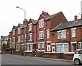
Sutton-in-Ashfield - 3-storey terrace on Kirkby Road
Image: © Dave Bevis
Taken: 23 Mar 2016
0.15 miles
2
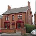
Sutton-in-Ashfield - Kirkby Road - No 86
Image: © Dave Bevis
Taken: 23 Mar 2016
0.20 miles
3
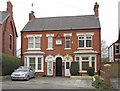
Sutton-in-Ashfield - Kirkby Road - Hawthorne Villas
House numbers 88 and 90. Date-stone shows a building date of 1909.
Image: © Dave Bevis
Taken: 23 Mar 2016
0.20 miles
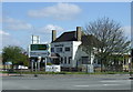
5
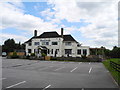
Fountain Bridge, Sutton in Ashfield (2)
Public House off Kirkby Road B6018.
Image: © John Topping
Taken: 25 Jun 2013
0.24 miles
6
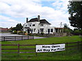
Fountain Bridge, Sutton in Ashfield (1)
Public House off Kirkby Road B6018.
Image: © John Topping
Taken: 25 Jun 2013
0.25 miles