IMAGES TAKEN NEAR TO
Kings Mill Road West, SUTTON-IN-ASHFIELD, NG17 1JS
Introduction
This page details the photographs taken nearby to Kings Mill Road West, NG17 1JS by members of the Geograph project.
The Geograph project started in 2005 with the aim of publishing, organising and preserving representative images for every square kilometre of Great Britain, Ireland and the Isle of Man.

There are currently over 7.5m images from over14,400 individuals and you can help contribute to the project by visiting https://www.geograph.org.uk
Image Map
Images are licensed for reuse under creativecommons.org/licenses/by-sa/2.0
Notes
- Clicking on the map will re-center to the selected point.
- The higher the marker number, the further away the image location is from the centre of the postcode.
Image Listing (11 Images Found)
Images are licensed for reuse under creativecommons.org/licenses/by-sa/2.0
Image
Details
Distance
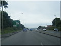
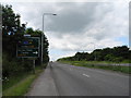
1

A38 approaching junction with B6023
Exit for Sutton in Ashfield town centre.
Image: © J.Hannan-Briggs
Taken: 23 Jun 2014
0.08 miles
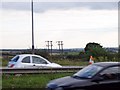
2
A38/B6023 junction, Sutton in Ashfield
Approaching the junction from the east.
Image: © John Topping
Taken: 25 Jun 2013
0.09 miles
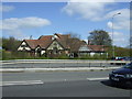
3
Road junction at The Snipe public house
From A38 eastbound
Image: © John Firth
Taken: 9 Jun 2013
0.10 miles
5
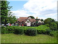
The Snipe, Sutton in Ashfield
Off the B6023 Alfreton Road.
Image: © John Topping
Taken: 25 Jun 2013
0.12 miles
6
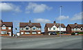
Houses on Alfreton Road, Sutton-in-Ashfield
Image: © JThomas
Taken: 18 Apr 2014
0.14 miles
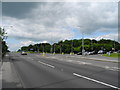
7
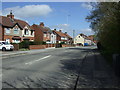
Alfreton Road (B6023), Sutton-in-Ashfield
Heading north.
Image: © JThomas
Taken: 18 Apr 2014
0.18 miles
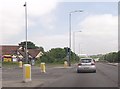
8
A38 Kings Road, Sutton in Ashfield (4)
Heading west towards the B6023 junction.
Image: © John Topping
Taken: 25 Jun 2013
0.19 miles