IMAGES TAKEN NEAR TO
Sutton Centre, High Pavement, SUTTON-IN-ASHFIELD, NG17 1EE
Introduction
This page details the photographs taken nearby to Sutton Centre, High Pavement, NG17 1EE by members of the Geograph project.
The Geograph project started in 2005 with the aim of publishing, organising and preserving representative images for every square kilometre of Great Britain, Ireland and the Isle of Man.

There are currently over 7.5m images from over14,400 individuals and you can help contribute to the project by visiting https://www.geograph.org.uk
Image Map
Images are licensed for reuse under creativecommons.org/licenses/by-sa/2.0
Notes
- Clicking on the map will re-center to the selected point.
- The higher the marker number, the further away the image location is from the centre of the postcode.
Image Listing (64 Images Found)
Images are licensed for reuse under creativecommons.org/licenses/by-sa/2.0
Image
Details
Distance
1
Sutton-in-Ashfield - Shakespeare Inn
On High Pavement.
Image: © Dave Bevis
Taken: 1 Apr 2013
0.03 miles
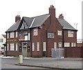
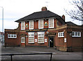
2

Sutton-in-Ashfield - Railway Inn
On High Pavement. The railway referred to is the former Midland Railway 0.75 mile branch from Sutton Junction to Sutton-in-Ashfield General Station. The station was situated on Station Street (to the left of the hotel).
Image: © Dave Bevis
Taken: 7 Feb 2013
0.04 miles
3
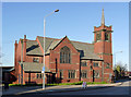
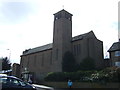
Sutton-in-Ashfield United Reformed Church, High Pavement
Built in 1905 as a Congregational church, designed by G Baines & Son of London in a free Gothic style favoured at the time. Listed Grade II.
Image: © Alan Murray-Rust
Taken: 5 Dec 2014
0.05 miles
4
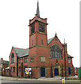
Sutton-in-Ashfield - United Reformed Church
This church was opened on April 4th 1906. The architects of the building were G. Baines & Son of London and the builders were J. Greenwood's of Mansfield.
Mainly because of the unusual nature of the pews inside, it is a Grade II Listed Building. See http://www.ashfield-dc.gov.uk/ccm/navigation/community-and-living/faiths--beliefs-and-religions/sutton-united-reformed-church/ .
Image: © Dave Bevis
Taken: 1 Apr 2013
0.05 miles
5
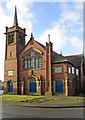
Sutton-in-Ashfield - United Reformed Church
On High Pavement. For another view and more information, please see Image
Image: © Dave Bevis
Taken: 24 Feb 2015
0.05 miles
7
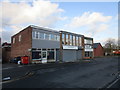
Businesses on New Street, Sutton in Ashfield
Image: © Jonathan Thacker
Taken: 12 Jan 2020
0.09 miles
8
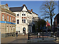
Albert Square, Sutton-in-Ashfield
No Eastenders here, this is the traditional centre of Sutton-in-Ashfield, now a pedestrianised shopping area.
Image: © Alan Murray-Rust
Taken: 5 Dec 2014
0.09 miles
9
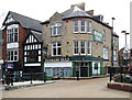
Sutton-in-Ashfield - Denmans Head
This former Home Brewery Co Ltd public house on Market Place has been converted to a Costa coffee house since this photo was taken. The name of Denmans Head has the following history (see http://www.nottshistory.org.uk/suttoninashfield1907/sutton3.htm ). "This old inn was, previous to A.D. 1820, known as the "King's Head," but on the trial of Queen Caroline, the then landlord, W. Cooper, was so much delighted with her defence by Mr. Denman (who was afterwards Lord Justice Denman) that he changed the name to the "Denman's Head" in his honour. The whole country was much excited over this trial and, on her acquittal, London was illuminated for three days. This Mr. Cooper was the father of the well-known, handsome, and highly respected surgeon of Mansfield, who was for many years its leading medical practitioner, and who was known all the district round as Dr. Cooper."
Image: © Dave Bevis
Taken: 8 Apr 2013
0.09 miles
10
St Joseph's Catholic Church
On Forest Street.
Image: © JThomas
Taken: 18 Apr 2014
0.10 miles