IMAGES TAKEN NEAR TO
Willowbridge Lane, SUTTON-IN-ASHFIELD, NG17 1DR
Introduction
This page details the photographs taken nearby to Willowbridge Lane, NG17 1DR by members of the Geograph project.
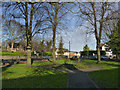
The Geograph project started in 2005 with the aim of publishing, organising and preserving representative images for every square kilometre of Great Britain, Ireland and the Isle of Man.

There are currently over 7.5m images from over14,400 individuals and you can help contribute to the project by visiting https://www.geograph.org.uk
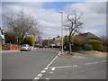
Image Map
Images are licensed for reuse under creativecommons.org/licenses/by-sa/2.0
Notes
- Clicking on the map will re-center to the selected point.
- The higher the marker number, the further away the image location is from the centre of the postcode.
Image Listing (55 Images Found)
Images are licensed for reuse under creativecommons.org/licenses/by-sa/2.0
Image
Details
Distance
1
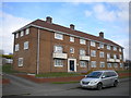
South elevation of West End Court, Sutton in Ashfield
Facing Willowbridge Lane.
Image: © Richard Vince
Taken: 6 Apr 2019
0.04 miles
2
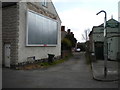
Mayfield Place, Sutton in Ashfield
Sneaking off Church Street.
Image: © Richard Vince
Taken: 6 Apr 2019
0.10 miles
3
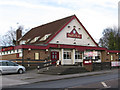
Sutton-in-Ashfield - Staff of Life
Pub on West End.
Image: © Dave Bevis
Taken: 7 Feb 2013
0.10 miles
4
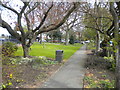
St Mary's Rest Garden, Sutton in Ashfield
In the triangle of Lammas Road (left), Church Street (out of frame to the right), and West End.
Image: © Richard Vince
Taken: 6 Apr 2019
0.11 miles
5
St Mary's Rest Garden
A small garden in a triangle between converging roads.
Image: © Alan Murray-Rust
Taken: 5 Dec 2014
0.13 miles
6
Junction of Church Street and Church Hill, Sutton in Ashfield
Church Street heads straight ahead into the town centre; Church Hill heads off downhill to the right.
Image: © Richard Vince
Taken: 6 Apr 2019
0.13 miles
7
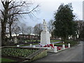
War Memorial, Sutton in Ashfield
First World War Memorial https://historicengland.org.uk/listing/the-list/list-entry/1275242
Image: © Jonathan Thacker
Taken: 12 Jan 2020
0.14 miles
8
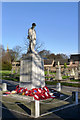
Sutton-in-Ashfield War Memorial
World War 1 memorial, situated close to the entrance to the Cemetery. Listed Grade II.
Image: © Alan Murray-Rust
Taken: 5 Dec 2014
0.14 miles
9

Sutton-in-Ashfield - Public Baths
On Brook Street. Opened in 1924. Closed on 30 October 2008. A replacement baths is provided at the Lammas Leisure Centre 400 metres away and is pictured at Image For more information on the Brook Street Baths, please see http://www.ournottinghamshire.org.uk/page_id__516.aspx .
Image: © Dave Bevis
Taken: 25 Oct 2008
0.15 miles
10

Sutton-in-Ashfield - Brook Street Court
This office building under construction, on Brook Street, has retained part of the frontage of the former swimming baths. These were closed in 2008 - see Image for more details.
Image: © Dave Bevis
Taken: 1 Mar 2015
0.15 miles