IMAGES TAKEN NEAR TO
Maid Marian Way, NOTTINGHAM, NG1 6HS
Introduction
This page details the photographs taken nearby to Maid Marian Way, NG1 6HS by members of the Geograph project.
The Geograph project started in 2005 with the aim of publishing, organising and preserving representative images for every square kilometre of Great Britain, Ireland and the Isle of Man.

There are currently over 7.5m images from over14,400 individuals and you can help contribute to the project by visiting https://www.geograph.org.uk
Image Map
Images are licensed for reuse under creativecommons.org/licenses/by-sa/2.0
Notes
- Clicking on the map will re-center to the selected point.
- The higher the marker number, the further away the image location is from the centre of the postcode.
Image Listing (1727 Images Found)
Images are licensed for reuse under creativecommons.org/licenses/by-sa/2.0
Image
Details
Distance

2
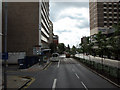
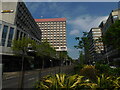
Maid Marian Way
Seen, in all its 1960s hideousness, from the top deck of the Edwalton bus.
Image: © John Sutton
Taken: 3 Sep 2009
0.01 miles
3
4550 Miles From Delhi
I wouldn't care to attempt the journey in the displayed form of transport.
An Indian restaurant on Maid Marian Way / Mount Street in Nottingham.
Image: © David Lally
Taken: 7 Nov 2009
0.01 miles
4
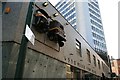
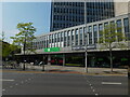
Newland House, Maid Marian Way, Nottingham
No doubt belonging to a major, and largely brutish, phase of urban development when the ring road was cut through in the early 1960s. Possibly the work of John Osborne & Son.
Image: © Stephen Richards
Taken: 17 Jun 2012
0.01 miles
7
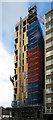
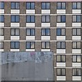
Student accommodation and shops, Maid Marian Way
Image: © Bryn Holmes
Taken: 1 May 2019
0.02 miles
8
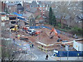
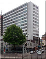
Nottingham, NG1 - Odeon cinema
Beyond the kerb of Maid Marion Way (A6008) the demolition of the former Odeon cinema site is almost complete. Beyond the security fencing to the right hand side of the site is a path leading away from the rear of some of the shops on Angel Row that is being maintained for emergency evacuation purposes but that is otherwise closed to the public. Behind the ivy-clad boundary brick wall is the garden of the still very active Bromley House subscription library, a plot (with the house included) that was purchased in 1820. During 2012 the library management committee mounted some resistance to planning proposals to allow a block of privately operated student apartments to be built on this site, in view of the fact that their peaceful garden was likely to be overlooked by such accommodation. It seems however, that their protests against this project have not succeeded. The "road" is Bromley Place, although it soon peters out to become a footpath-only leading to Angel Row.
Image: © David Hallam-Jones
Taken: 26 Nov 2012
0.02 miles
9
New student apartments on site of Odeon cinema
Image: © SK53
Taken: 10 Feb 2014
0.02 miles
10
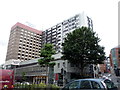
Buildings on Maid Marian Way
Britannia Hotel partially obscured by an NCP car park.
Image: © David Lally
Taken: 31 Mar 2017
0.02 miles