IMAGES TAKEN NEAR TO
Maid Marian Way, NOTTINGHAM, NG1 6GQ
Introduction
This page details the photographs taken nearby to Maid Marian Way, NG1 6GQ by members of the Geograph project.
The Geograph project started in 2005 with the aim of publishing, organising and preserving representative images for every square kilometre of Great Britain, Ireland and the Isle of Man.

There are currently over 7.5m images from over14,400 individuals and you can help contribute to the project by visiting https://www.geograph.org.uk
Image Map
Images are licensed for reuse under creativecommons.org/licenses/by-sa/2.0
Notes
- Clicking on the map will re-center to the selected point.
- The higher the marker number, the further away the image location is from the centre of the postcode.
Image Listing (1850 Images Found)
Images are licensed for reuse under creativecommons.org/licenses/by-sa/2.0
Image
Details
Distance
1
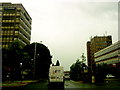
Maid Marian Way
Once dubbed the ugliest street in Britain. Not much better now.
Image: © Andrew Abbott
Taken: 6 Jun 2010
0.01 miles
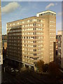
2
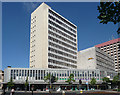
Newtown House, Maid Marian Way, Nottingham
Built c1962 to the designs of John P. Osborne & Son, and, together with the adjacent car park and (slightly later) egregious hotel beyond, part of a major scheme around the time that this major chunk of the inner ring road was cut through. Both the offices and car park have hexagonal openings.
Image: © Stephen Richards
Taken: 19 Jun 2012
0.01 miles
3
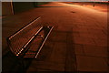
Stainless Steel Bench, Maid Marion Way
This junction of Friar Lane and Maid Marion Way was originally a roundabout with subways. The centre was occupied by a newspaper kiosk.
This is now all filled-in.
Image: © David Lally
Taken: 10 Sep 2008
0.01 miles
4
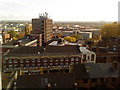
Looking south from the St. James' Street Car Park
Image: © Andrew Abbott
Taken: 30 Oct 2010
0.02 miles
5
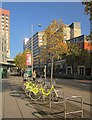
Maid Marian Way, Nottingham
Any townscape less likely to be associated with medieval romanticism is hard to imagine. Here are cycle racks by the junction with Friar Lane.
Image: © Derek Harper
Taken: 12 Oct 2014
0.02 miles
6
Maid Marian Way, Nottingham
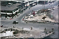
The scheme to cut a new road through the centre of Nottingham from Chapel Bar to Canal Street was first mooted by the city council in 1945, but it was a controversial plan from the start. Many felt that addressing the serious post-war housing shortage should have had a higher priority and there was also alarm at the number of historic properties that would be demolished. In the end the road was built in the 1960s and was christened Maid Marian Way. It did allow some busy city centre shopping streets to be pedestrianised but the road itself was characterised by a seemingly miscellaneous collection of modern and old buildings with little attempt at architectural harmony; it was famously described as 'the ugliest street in Europe' - a remark possibly attributable to Professor Arthur Ling of Nottingham University's Department of Architecture and Civic Planning.
In this view from 1965 construction work is taking place at the junction with Friar Lane. A roundabout was built here with a series of pedestrian underpasses, although in recent years that has been removed. Note the vintage taxi passing through the roadworks.
Image: © Derek McKay
Taken: Unknown
0.02 miles
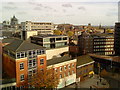
9
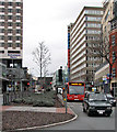
Maid Marian Way
Looking towards Derby Road from the Friar Lane crossroads on an overcast February afternoon. To the left of the undistinguished block above the bus is the scaffolding of new student flats being built on the Odeon cinema site.
Image: © John Sutton
Taken: 8 Feb 2014
0.02 miles
10
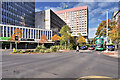
Maid Marian Way, Nottingham
Dual carriageway (A6008) surrounded by high-rise buildings.
Image: © David Dixon
Taken: 13 Oct 2022
0.02 miles