IMAGES TAKEN NEAR TO
Maid Marian Way, NOTTINGHAM, NG1 6GE
Introduction
This page details the photographs taken nearby to Maid Marian Way, NG1 6GE by members of the Geograph project.
The Geograph project started in 2005 with the aim of publishing, organising and preserving representative images for every square kilometre of Great Britain, Ireland and the Isle of Man.

There are currently over 7.5m images from over14,400 individuals and you can help contribute to the project by visiting https://www.geograph.org.uk
Image Map
Images are licensed for reuse under creativecommons.org/licenses/by-sa/2.0
Notes
- Clicking on the map will re-center to the selected point.
- The higher the marker number, the further away the image location is from the centre of the postcode.
Image Listing (1948 Images Found)
Images are licensed for reuse under creativecommons.org/licenses/by-sa/2.0
Image
Details
Distance
1
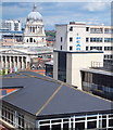
Nottingham, NG1 (Old Mkt Square area)
A view of Nottingham's Council House with its iconic 61 metre (200 ft) high dome forming the centrepiece on this section of the skyline. This building was constructed between 1927-29 and it is claimed that the chimes of the "Little John" bell in the dome can be heard over a distance of seven miles.
Image: © David Hallam-Jones
Taken: 24 Jun 2012
0.01 miles
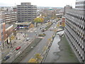
5
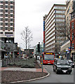
Maid Marian Way
Looking towards Derby Road from the Friar Lane crossroads on an overcast February afternoon. To the left of the undistinguished block above the bus is the scaffolding of new student flats being built on the Odeon cinema site.
Image: © John Sutton
Taken: 8 Feb 2014
0.02 miles
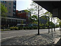
6
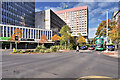
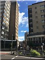
Maid Marian Way, Nottingham
Dual carriageway (A6008) surrounded by high-rise buildings.
Image: © David Dixon
Taken: 13 Oct 2022
0.02 miles
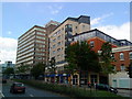
7
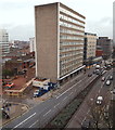
Nottingham, NG1 - Maid Marian Way
The most dominant building in this picture is the Park Plaza Hotel that was opened in 2002. The road branching off to the left on this side of it is Bromley Place, a road that terminates halfway along its length and becomes a footpath that runs on until it reaches Angel Row. The flattened area behind this end of the hotel represents the remains of a part of the former Odeon cinema that has been demolished to make way for a complex that will contain a small number of shops on Angel Row (and perhaps on Maid Marian Way too) and a block of student apartments. St James' Street, beyond the hotel, was bisected by this dual carriageway in 1964.
Image: © David Hallam-Jones
Taken: 26 Nov 2012
0.02 miles
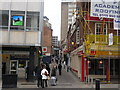
9
St James's Street
Looking towards the Old Market Square part of the street from across Maid Marion Way which bisects the much older thoroughfare.
Image: © David Lally
Taken: 5 Aug 2017
0.02 miles
10
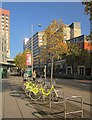
Maid Marian Way, Nottingham
Any townscape less likely to be associated with medieval romanticism is hard to imagine. Here are cycle racks by the junction with Friar Lane.
Image: © Derek Harper
Taken: 12 Oct 2014
0.02 miles