IMAGES TAKEN NEAR TO
Maid Marian Way, NOTTINGHAM, NG1 6GD
Introduction
This page details the photographs taken nearby to Maid Marian Way, NG1 6GD by members of the Geograph project.
The Geograph project started in 2005 with the aim of publishing, organising and preserving representative images for every square kilometre of Great Britain, Ireland and the Isle of Man.

There are currently over 7.5m images from over14,400 individuals and you can help contribute to the project by visiting https://www.geograph.org.uk
Image Map
Images are licensed for reuse under creativecommons.org/licenses/by-sa/2.0
Notes
- Clicking on the map will re-center to the selected point.
- The higher the marker number, the further away the image location is from the centre of the postcode.
Image Listing (1900 Images Found)
Images are licensed for reuse under creativecommons.org/licenses/by-sa/2.0
Image
Details
Distance
1
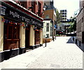
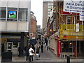
Tower block from St James's Street
Here St James's Street is a narrow alley, thankfully pedestrianised.
See http://www.geograph.org.uk/photo/3965890 and http://www.geograph.org.uk/photo/1911403
Image: © David Lally
Taken: 22 Apr 2016
0.01 miles
2
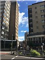
Nottingham, NG1 (St James' St)
The "One Way" sign in the middle of the Maid Marian Way (A6008) dual carriageway highlights the way in which St James' Street was chopped in two, with its higher section ascending towards Standard Hill. This street, which was known as St James' Lane until the early 1800, was originally called Jam Gate or Jamgate. In the mid 18th century a pub called "The Talbot" existed on the site of the one seen here although by 1799 it was known as "The News House" in recognition of its links with the embryonic newspaper industry. "The Nottingham Post" and "The Nottingham Courant" were the first (single sheet format) newspapers, carrying news harvested from the London papers. "The Nottingham Journal" and "The Evening Post" came later.
Image: © David Hallam-Jones
Taken: 24 Jun 2012
0.01 miles
3
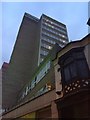
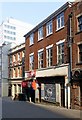
41 Maid Marian Way, Nottingham
Dating from the late 1950s or early 1960s when this major chunk of the inner ring road was cut through. The contemporary buildings lining the road are not generally very distinguished. I find this simple brick and stone slab inoffensive, if not very exciting. Nottinghamians who remember what was here before may take a different view.
Currently the Park Plaza Hotel.
Image: © Stephen Richards
Taken: 18 Jun 2012
0.01 miles
6
St James's Street
Looking towards the Old Market Square part of the street from across Maid Marion Way which bisects the much older thoroughfare.
Image: © David Lally
Taken: 5 Aug 2017
0.01 miles
7
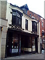
17 St James' Street, Nottingham
Georgian town house, later a warehouse, now cafe and snooker club. c1770, restored and altered c1980, Listed Grade II.
Image: © Alan Murray-Rust
Taken: 8 Apr 2019
0.02 miles
8
Nottingham, NG1 - Rear of Angel Row
Maid Marion Way (the A6008) lies behind the photographer. Taken from the public viewing area, this photo highlights some of the demolition work on the former Odeon cinema site that has occurred during the previous 6-8 weeks. Beyond the security fencing is a path leading away from the rear of some of the shops on Angel Row that is being maintained for emergency evacuation purposes, but is otherwise closed to the public. Beyond the ivy-clad boundary brick wall is the garden of the Bromley House subscription library. Bromley House was built in 1752 for Sir George Smith and was his family residence until 1804 when it was purchased for the creation of a subscription library, a facility which still exists to this day. In 2012 the library management committee mounted some resistance to planning proposals that would allow a block of privately operated student apartments to be built on this demolition site, in view of the fact that their peaceful garden was likely to be overlooked by such accommodation. Their protests were unsuccessful and a student accommodation block now occupies this demolition site.
Image: © David Hallam-Jones
Taken: 26 Nov 2012
0.02 miles
10
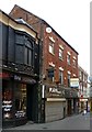
22 & 24 St James' Street, Nottingham
A pair of late Georgian houses, c.1820 with later shop fronts, Listed Grade II.
Image: © Alan Murray-Rust
Taken: 8 Apr 2019
0.02 miles